More than 5,000 metres of altitude gain, 100 kilometres of hiking, eight mountain huts – and all in just one valley! The Stubai High Trail is one of the most beautiful high-altitude trails in the alpine region and leads through the Stubai Alps. Among the many highlights are the majestic glacier views between the Bremer Hütte and the Dresdner Hütte. This high-altitude walking trail is classified as a challenging “black” route and leads exclusively through alpine terrain. For this reason, sure-footedness, appropriate levels of fitness, a good head for heights and the right equipment are prerequisites before attempting to explore the mighty mountain world of the Stubai Valley along the Stubai High Trail. The trail can be walked in both directions. Another special feature of the Stubai High Trail is that the hike can be started and terminated at any hut. This means hikers can complete as many stages of this long-distance trail as they want.

Long-Distance Hike

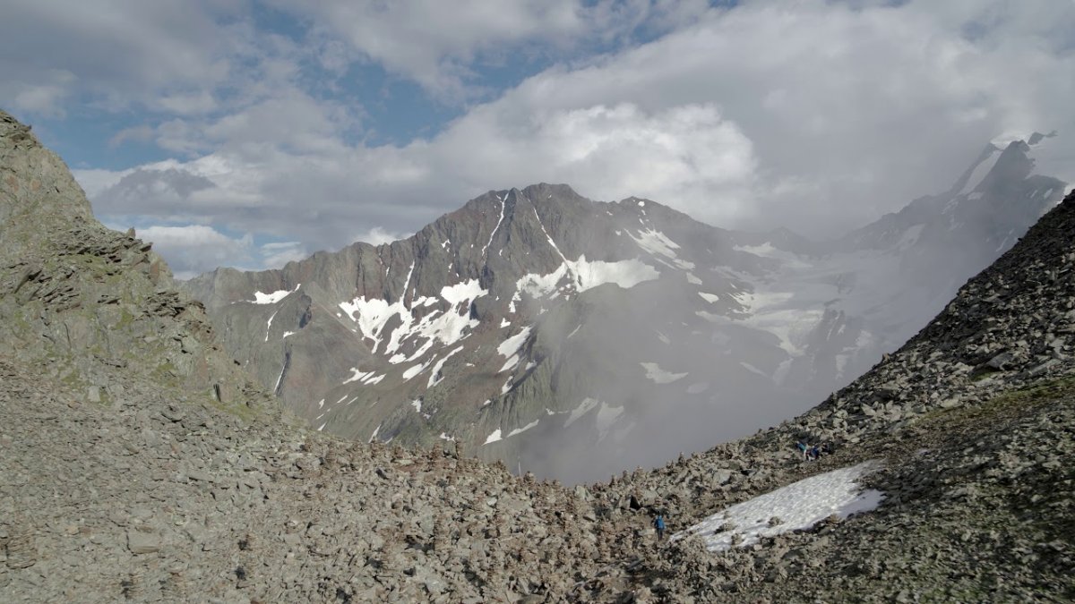
"The incredible thing about the Stubai High Trail is the majestic view it offers of the mountains and glaciers over 3,000m. The section between the Dresdnerhütte and the Bremer Hütte huts enables you to get particularly close to the glaciers."


Starting point
Top of Kreuzjoch cable car / Starkenburger Hütte
Finishing point
Innsbrucker Hütte
Mountain chain
Stubai Alps
Length
78 km
Duration
7 day(s)
Features
- Wheelchair-accessible Hiking Route
- Circular hike
Difficulty rating
difficult (black trails)
Altitude
2,881m 973m
Elevation uphill 5,081m
Vertical metres downhill 6,225m
Fitness level
Technique
Best time of year
Jan
Feb
Mar
Apr
May
Jun
Jul
Aug
Sep
Oct
Nov
Dec
* These are approximate values and recommendations. Please take your personal fitness level, technical ability and the current weather conditions into account. Tirol Werbung cannot guarantee that the information provided is correct and accepts no liability.
Public transport
- Accessible using public transport
Parking
Parking at the Kreuzjochbahn cable car
Places serving food & drink
- Ascent: Panoramarestaurant Kreuzjoch, Sennjochhütte, Starkenburger Hütte
- Stage 1: Seducker Hochalm, Franz-Senn-Hütte
- Stage 2: Neue Regensburger Hütte
- Stage 3: Dresdner Hütte
- Stage 4: Sulzenau-Hütte
- Stage 5: Nürnberger Hütte
- Stage 6: Bremer Hütte
- Stage 7: Innsbrucker Hütte
- Descent: Karalm, Pinnisalm, Issenangeralm, Panoramarestaurant Elfer
Downloads
Trail description
Ascent from the valley: Kreuzjoch cable car – Starkenberger Hütte
Uphill/downhill: 394/263 vertical metres, walking time: 2.5 hours, distance: 4.4 kilometres
The ascent to the Starkenburger Hütte can be made by either taking the Kreuzjoch cable car from Fulpmes to the top station of the Schlick 2000 lifts and then continuing on foot along the footpath (walking time: 1 ½ to 2 hours), or from Neustift via the Kartnall Höfe (farmsteads) and the Forcherkogel mountain, or direct through the Lärchenwiesen meadows, to the Starkenberger Hütte.
Stage 1: Starkenburger Hütte – Franz-Senn-Hütte
Uphill/downhill: 739/829 vertical metres, walking time: 6 hours, distance: 15.3 kilometres
The first stage of the Stubai High Trail leads from the Starkenburger Hütte to just below the Kalkkögel mountain and past the Seejöchl ridge above the Schlickersee lake. The route then carries on to the Sendersjöchl ridge, down to the Rote Wand, past the Seducker Hochalm and finally along the slopes of the inner Oberbergtal Valley to the Franz-Senn-Hütte.
Stage 2: Franz-Senn-Hütte – Neue Regensburger Hütte
Uphill/downhill: 671/534 vertical metres, walking time: 4.5 hours, distance: 9.1 kilometres
From the Franz-Senn-Hütte, the second stage leads initially out of the valley towards an area called Kuhgschwetz – from where the ascent to Schrimmennieder begins. After 20 minutes’ walk above Schrimmennieder you will reach the Basslerjoch ridge (2,829 m), where stunning views of the Stubai Main Ridge can be enjoyed. After walking back down to Schrimmennieder the route takes you along a by-path, which is a virtually flat trail leading from the Milderaunalm into the valley and the Neue Regensburger Hütte.
Stage 3: Neue Regensburger Hütte – Dresdner Hütte
Uphill/downhill: 1,009/991 vertical metres, walking time: 7 hours, distance: 12.9 kilometres
Stage three of the Stubai High Trail starts from the Neue Regensburger Hütte and leads past the Falbesonersee lake, before heading up a steep ascent to Grawagrubennieder. From there the trail takes you under the “tongue” of the Grawawandferner glacier and past the Mutterbergersee lake before an easy descent leads to the base of the Glamergrube. After a climb, follow the trail through the Wilde Grube and along a ridge before heading down to the Dresdner Hütte.
Stage 4: Dresdner Hütte – Sulzenau-Hütte
Uphill/downhill: 400/517 vertical metres, walking time: 3 hours, distance: 4.6 kilometres
The fourth stage leads initially from the Dresdner Hütte to the middle station of the Stubai Glacier Lifts, before heading in the direction of the Fernaubach river. After an uphill climb you will reach a fork in the trail signposted "Trögler" or "Peiljoch". Experienced hikers can climb the Trögler (walking time: 2 hours, descent to the Sulzenau-Hütte: 1 hour). The regular route continues along a steep but well-secured trail. After hiking down the winding trail and crossing the ice moraines of the Sulzenau glacier, you will finally reach the Sulzenau-Hütte.
Stage 5: Sulzenau-Hütte – Nürnberger Hütte
Uphill/downhill: 472/382 vertical metres, walking time: 4 hours, distance: 4.5 kilometres
The fifth stage leads from the Sulzenau-Hütte to the Grünausee, the largest lake in the Stubai Alps, and onwards in a north-easterly direction to the Nürnberger Hütte. This stage also offers hikers the opportunity to climb two mountains: the Mairspitze and the Gamsspitzl.
Stage 6: Nürnberger Hütte – Bremer Hütte
Uphill/downhill: 631/500 vertical metres, walking time: 3 hours 50 minutes, length: 5.9 kilometres
During this stage of the Stubai High Trail you will be able to see at first hand the formative influence glaciers have had on the landscape. From the Nürnberger Hütte, the trail leads initially over an extensive area of glacial erosion, before leading onto the Zollhütte at Simmingjöch and your final destination for this stage, the Bremer Hütte.
Stage 7: Bremer Hütte – Innsbrucker Hütte
Uphill/downhill: 850/894 vertical metres, walking time: 6 hours, distance: 10.3 kilometres
On good weather days, more experienced hikers can start this stage of the tour by climbing down a short, well-secured with steel cable and rungs, hollow to the Lauterersee lake. Those less experienced should descend via the regular route below the small cable car used to transport material and goods up to the hut. The route continues on to the Trauljöch ridge and a crosses the large and cable-secured Trailgrube, followed by an ascent of the Wasenwand to the Pramarspitze. Carry on over the Glättegrube and, after a final climb at the Sendesgrad, the trail leads past the foot of the Habicht mountain and Alfaiersee lake and on to the Innsbrucker Hütte.
Descent into the valley: Innsbrucker Hütte – Neder
Downhill: 1,391 vertical metres, walking time: 4 hours, distance: 10.9 kilometres
The descent from the Innsbrucker Hütte into the Stubai Valley can be made either through the Pinnistal Valley to Neder (walking time: 1.5 hours) or via the top station of the Elfer lifts (walking time: 2.5 hours), from where you can catch the cable car back down to Neustift.
Places along the route


Hiking trails in this region

Neustift im Stubaital
The WildeWasserWeg trail in the Stubai Valley invites hikers to discover…

Fulpmes
This challenging two-day trek at the foot of the Kalkkögel Mountains in the…

Neustift im Stubaital
The Elferspitze mountain in the Stubai Valley takes its name, which…
