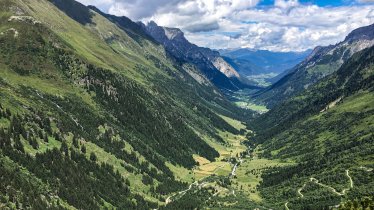
Stage 1:
Vals – Geraer Hütte
Uphill: 1,000 vertical metres, walking time: 3 hours
From the Gasthaus Touristenrast at the end of the Valsertal Valley (bus stop and free car park at the Nockeralmen) hikers walk along a wide path (502) for around an hour up to a small mechanical cable car used to transport material up to the Geraer Hütte hut. From the bottom of this cable car, take the winding trail up to the edge of the forest and then, still on trail 502, all the way to the Geraer Hütte hut (2,324 metres).
Stage 2:
Geraer Hütte – Tuxerjochhaus
Uphill/downhill: 500/500 vertical metres, walking time: 5 hours
From the Geraer Hütte hut, head towards the Steinernes Lamm (527) and over glacier moraines through the Vordere Höllwand and on to the Kleegrubenscharte, Kasererscharte and Frauenwand. After crossing a number of pastures and meadows hikers will reach the Tuxerjochhaus (2,313 metres).
Stage 3:
Tuxerjochhaus – Friesenberghaus
Uphill/downhill: 910/740 vertical metres, walking time: 5 hours
From the Tuxerjochhaus, take trail 326 downhill to the Lärmstange mountain, before heading in a southeasterly direction to the Spannagelhaus (2,531 metres) and on to the Friesenbergscharte (2,911 metres). Here, at the highest point of the Peter Habeler Hike, hikers can enjoy fantastic views of the surrounding mountains. The trail then winds its way down via several swichbacks to the Friesenberghaus (2,498 metres).
Stage 4:
Friesenberghaus – Olpererhütte
Uphill/downhill: 220/310 vertical metres, walking time: 2.5 hours
From the Friesenberghaus, head downhill past the Friesenbergsee lake and then back uphill via a series of steep switchback corners. The trail then joins the well-known Berlin High Trail (trail number 526) for a section before taking hikers to the Olpererhütte (2,389 metres).
Stage 5: Olpererhütte – Pfitscherjochhaus
Uphill/downhill: 430/570 vertical metres, walking time: 3.5 hours
From the Olpererhütte (2,389 metres) follow trail 502 towards the Unterschrammachkar ridge (2,280 metres). After a short ascent in the shadow of the Ameiskopf mountain (2,400 metres) trail 528 takes hikers to the Kastenschneid and below the Stamplkees glacier all the way to the Pfitscherjochhaus (2,276 metres).
Stage 6:
Pfitscherjochhaus – Landshuter Europa-Hütte
Uphill/downhill: 675/250 vertical metres, walking time: 3 hours
From the Pfitscherjochhaus, the trail leads past several small lakes and through a barren rocky landscape following the Landshut High Trail (3 and 528) via the Friedrichshöhe to the Landshuter Europa-Hütte (2,693 metres).
Stage 7:
Landshuter Europa-Hütte – Vals
Downhill: 1,300 vertical metres, walking time: 4 hours
From the Landshuter Europa-Hütte the "Geistbeckweg" trail (529) takes hikers past the Sumpfschaftl (2,666 metres) and on over the Lange Wand to the Innere Zeischalm and finally back to the starting point in Vals.
For details on the different ways of accessing the Peter Habeler Hike visit www.mayrhofen.at