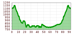
Road bike tour Lake Tour

Tannheim / Ammergauer Alpen
Difficulty ratings: medium
Route length: 92.5 km
Duration: 4:30 h

Short description:Start at the Tourism Information Office in Tannheim towards the East. At the intersection Grän/Haldensee turn left on to the Road L261 through the Engetal (valley) downhill to the former customs house "Fallmühle"…Technique: ****Quality of experience: *****Recommended season:AprilMayJuneJulyAugustSeptemberOctoberProperties:LoopRefreshment stops available

Tour information

  • Requirement: medium
  • Length: 92.5 km
  • Duration: 4:30 h
  • Elevation uphill:800 hm
  • Elevation downhill:800 hm
Highest point1,153 m
  • Fitness level 3 / 6

Features

  • Circular route

Best time of year

  • January
  • February
  • March
  • April
  • May
  • June
  • July
  • August
  • September
  • October
  • November
  • December
Source: Tannheimer Tal

Description

Description:
Start at the Tourism Information Office in Tannheim towards the East. At the intersection Grän/Haldensee turn left on to the Road L261 through the Engetal (valley) downhill to the former customs house "Fallmühle" to Pfronten. At the entrance to Pfronten, turn left and follow the main street to Pfronten-Ried. Turn left at the intersection. After a 90-degree left curve, turn right towards Füssen. Take a right at the traffic circle and continue along the road until Weißensee.

At the end oft he village, turn left and head via Schwarzenbach and Hopferried to Hopferau. Continue on to Hopfen am See and Osterreinen. Staying on the same road follow it until Roßhaupten. In Roßhaupten, keep right and ride along the Forggensee lake shore to Bayerniederhofen. In the middle of town, turn right on to the bike trail. Past the Bannwaldsee via Mühlberg and Waltenhofen in the direction of Schwangau. Before the Lechbrücke (bridge), turn right towards Vils and Pfronten. After passing the church in Pfronten-Steinach, turn right towards the Tannheim Valley uphill through the Engetal on the Road L261 to Grän. At the intersection Grän/Haldensee, turn right back to Tannheim and the starting point.

Directions:
Start bei der Tourismusinformation in Tannheim in Richtung Osten. An der Kreuzung Grän/Haldensee links abbiegen auf die L261 und durch das Engetal zum ehemaligen Zollamt Fallmühle hinab nach Pfronten. Am Ortseingang von Pfronten links abbiegen und dem Straßenverlauf folgend bis Pfronten-Ried. Bei der Kreuzung links abbiegen. Nach einer 90 Grad Linkskurve rechts abbiegen Richtung Füssen. Beim Kreisverkehr rechts und dem Straßenverlauf folgend bis nach Weißensee. Am Ortsende links abbiegen und über Schwarzenbach und Hopferried nach Hopferau. Weiter nach Hopfen am See, am Ortsende links und nach 200 Meter rechts (rechts bei der Kirche) abbiegen Richtung Füssen. An der Kreuzung der B16 links Richtung Marktoberdorf und parallel auf den Radweg einbiegen. Dem Radweg folgend bis nach Roßhaupten, dort rechts halten und weiter entlang des Forgensees nach Bayerniederhofen. Am Ortsende, nach einer kurzen Abfahrt, rechts auf den Radweg auffahren, vorbei am Bannwaldsee und über Brunnen und Waltenhofen Richtung Horn. Dort auf die B17 auffahren, vor der Lechbrücke links abbiegen nach Vils und weiter Richtung Pfronten. In Pfronten Steinach nach der Kirche links abbiegen Richtung Tannheimer Tal durchs Engetal auf der L261 nach Grän. An der Kreuzung Grän/Haldensee rechts abbiegen nach Tannheim bis zum Ausgangspunkt.Safety guidelines:
Traffic regulations (StVO) must be adhered to at all times.Equipment:
A Roadbike is recommended.

Every participant rides at his/her own risk.

Additional information:
Tourismusverband Tannheimer Tal

More tours in the surrounding area

Newsletter

The mountain is calling? So does our newsletter!

In our monthly newsletter we reveal the best holiday tips for Tyrol.