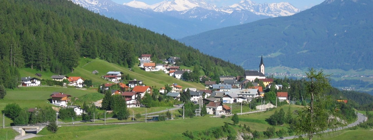
Weather in Reith bei Seefeld, 1,130 m
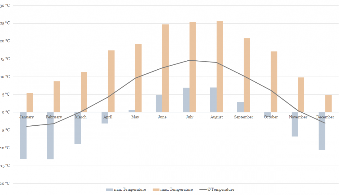
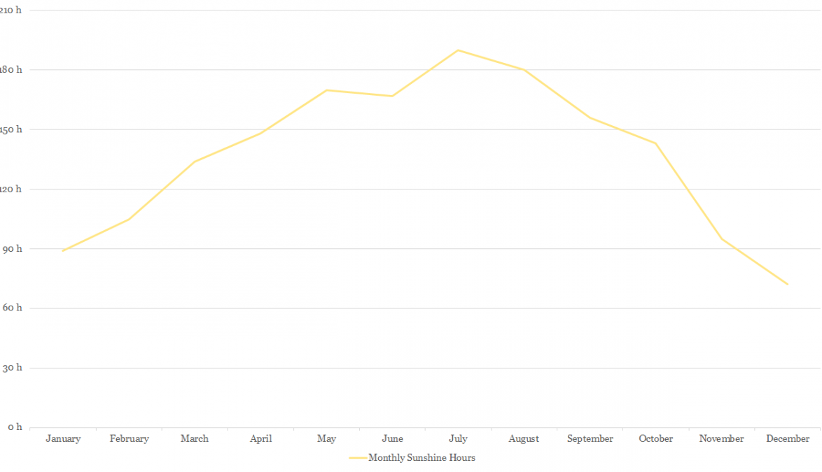
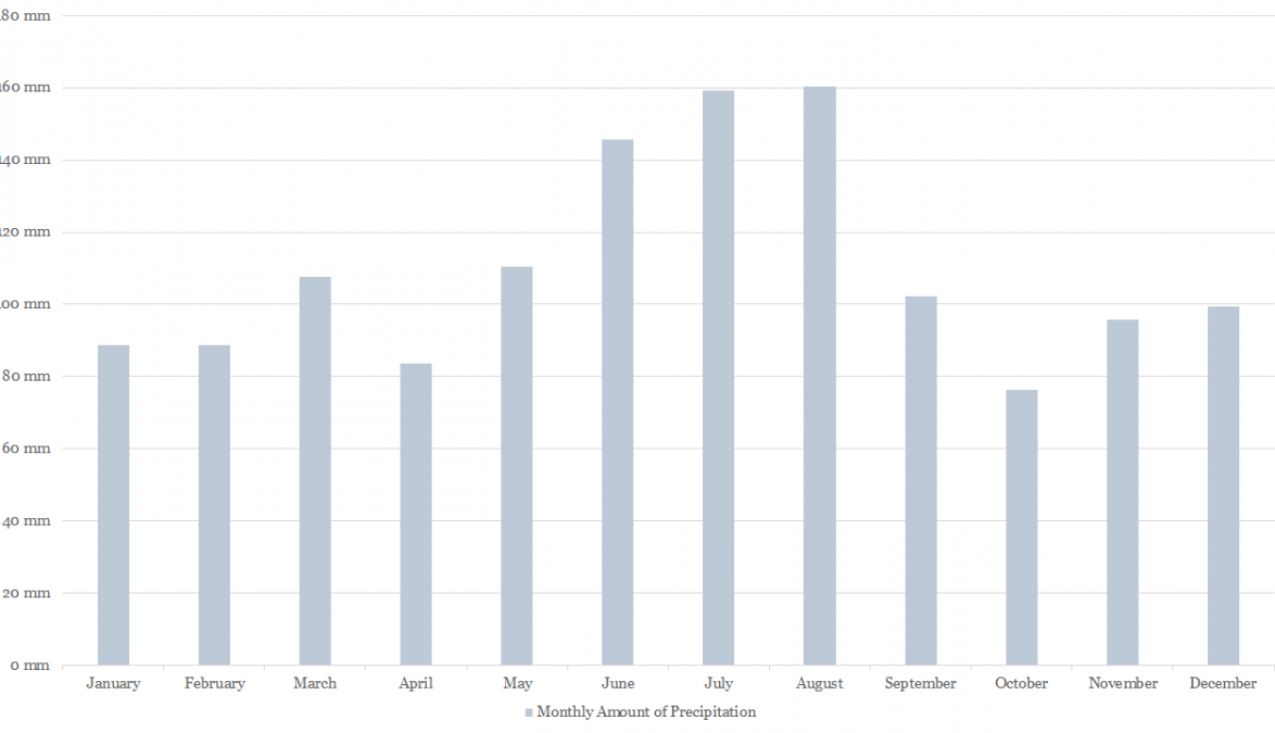
Here you will find the latest information on the weather in Reith bei Seefeld, Austria. As well as a summary of the current weather conditions, you will also receive a weather forecast for the next nine days. Use the hour-by-hour prediction to keep an eye on the development of the weather throughout the day. A number of webcams are also available to see the weather in real time. Climate diagrams show typical weather conditions in Reith bei Seefeld at different times of the year.
00:00

0°C
Precipitation: 5%
Wind: 5 km/h
01:00

-1°C
Precipitation: 10%
Wind: 5 km/h
02:00

-1°C
Precipitation: 20%
Wind: 5 km/h
03:00

-1°C
Precipitation: 5%
Wind: 5 km/h
04:00

-1°C
Precipitation: 5%
Wind: 5 km/h
05:00

-1°C
Precipitation: 20%
Wind: 5 km/h
06:00

-1°C
Precipitation: 25%
Wind: 5 km/h
07:00

0°C
Precipitation: 25%
Wind: 5 km/h
08:00

0°C
Precipitation: 20%
Wind: 5 km/h
09:00

1°C
Precipitation: 10%
Wind: 5 km/h
10:00

2°C
Precipitation: 45%
Wind: 5 km/h
11:00

2°C
Precipitation: 40%
Wind: 5 km/h
12:00

3°C
Precipitation: 70%
Wind: 10 km/h
13:00

3°C
Precipitation: 30%
Wind: 10 km/h
14:00

3°C
Precipitation: 30%
Wind: 5 km/h
15:00

3°C
Precipitation: 35%
Wind: 5 km/h
16:00

2°C
Precipitation: 55%
Wind: 5 km/h
17:00

1°C
Precipitation: 60%
Wind: 10 km/h
18:00

0°C
Precipitation: 25%
Wind: 5 km/h
19:00

0°C
Precipitation: 35%
Wind: 5 km/h
20:00

0°C
Precipitation: 60%
Wind: 5 km/h
21:00

0°C
Precipitation: 35%
Wind: 5 km/h
22:00

0°C
Precipitation: 55%
Wind: 5 km/h
23:00

0°C
Precipitation: 45%
Wind: 5 km/h
00:00

0°C
Precipitation: 40%
Wind: 5 km/h
01:00

0°C
Precipitation: 35%
Wind: 5 km/h
02:00

0°C
Precipitation: 25%
Wind: 5 km/h
03:00

0°C
Precipitation: 5%
Wind: 5 km/h
04:00

0°C
Precipitation: 5%
Wind: 5 km/h
05:00

0°C
Precipitation: 5%
Wind: 5 km/h
06:00

1°C
Precipitation: 95%
Wind: 5 km/h
07:00

2°C
Precipitation: 95%
Wind: 5 km/h
08:00

3°C
Precipitation: 95%
Wind: 10 km/h
09:00

4°C
Precipitation: 100%
Wind: 15 km/h
10:00

4°C
Precipitation: 75%
Wind: 20 km/h
11:00

3°C
Precipitation: 75%
Wind: 20 km/h
12:00

3°C
Precipitation: 75%
Wind: 20 km/h
13:00

3°C
Precipitation: 60%
Wind: 15 km/h
14:00

2°C
Precipitation: 40%
Wind: 15 km/h
15:00

2°C
Precipitation: 10%
Wind: 15 km/h
16:00

2°C
Precipitation: 5%
Wind: 15 km/h
17:00

2°C
Precipitation: 95%
Wind: 10 km/h
18:00

1°C
Precipitation: 95%
Wind: 5 km/h
19:00

1°C
Precipitation: 95%
Wind: 0 km/h
20:00

1°C
Precipitation: 95%
Wind: 0 km/h
21:00

1°C
Precipitation: 95%
Wind: 0 km/h
22:00

1°C
Precipitation: 95%
Wind: 5 km/h
23:00

1°C
Precipitation: 95%
Wind: 5 km/h
Saturday, Apr 20, 2024
morning, 7:00 - 11:00

-1°C
95%
5 km/h
afternoon, 12:00 - 17:00

2°C
95%
10 km/h
evening, 18:00 - 22:00

0°C
95%
10 km/h
Thick clouds and widespread snowfall throughout the whole day.
Sunday, Apr 21, 2024
morning, 7:00 - 11:00

-3°C
95%
5 km/h
afternoon, 12:00 - 17:00

2°C
95%
10 km/h
evening, 18:00 - 22:00

-1°C
65%
10 km/h
Frequent snowfall, but a slight chance of sunshine in the afternoon.
Monday, Apr 22, 2024
morning, 7:00 - 11:00

-4°C
20%
5 km/h
afternoon, 12:00 - 17:00

3°C
15%
5 km/h
evening, 18:00 - 22:00

1°C
30%
5 km/h
Rather cloudy in the morning, then sunny spells will develop gradually.
Tuesday, Apr 23, 2024
morning, 7:00 - 11:00

-2°C
10%
5 km/h
afternoon, 12:00 - 17:00

6°C
15%
5 km/h
evening, 18:00 - 22:00

3°C
35%
5 km/h
Morning clouds will clear gradually. Then frequent sunny periods.
Wednesday, Apr 24, 2024
morning, 7:00 - 11:00

1°C
30%
0 km/h
afternoon, 12:00 - 17:00

4°C
35%
5 km/h
evening, 18:00 - 22:00

3°C
45%
5 km/h
The day will be dry, but mostly cloudy with occasional sunny spells.
Thursday, Apr 25, 2024
morning, 7:00 - 11:00

1°C
40%
0 km/h
afternoon, 12:00 - 17:00

5°C
45%
10 km/h
evening, 18:00 - 22:00

3°C
40%
5 km/h
The day will be dry, but mostly cloudy with occasional sunny spells.
Friday, Apr 26, 2024
morning, 7:00 - 11:00

1°C
25%
5 km/h
afternoon, 12:00 - 17:00

6°C
25%
5 km/h
evening, 18:00 - 22:00

4°C
30%
5 km/h
Dry and partly sunny throughout the day, with cloudy periods from time to time.
Current webcams in Reith bei Seefeld
How did you like this article?
Is your inbox in need of a holiday?
Then subscribe to our weekly newsletter full of exclusive holiday tips from Tirol!
🏔️❤️


