Challenging mountain tour from the Karwendelhaus via the west ridge to the Birkkarspitze, offering breathtaking views of the surrounding alpine panorama, followed by a descent into the Hinterautal.

Mountain paths, and gravel trails.
All current information about the trail closures in the Region Seefeld can be found here.
Have you been out and about in the Region and discovered a spot that we should rework or repair? Fill out the form "Report a danger zone" and let us know where work is needed.
Sturdy hiking shoes, functional clothing, a backpack, water, snacks, alpine experience, and sure-footedness are necessary for this tour!
Also recommended: a hiking map or GPS, a first aid kit, sun protection, hiking poles, and an emergency blanket.
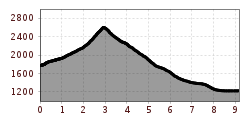
Next to the Karwendelhaus, the marked trail to the Birkkarspitze begins. The path starts steep and passes through rocky terrain, with some sections secured by cables. It winds past dwarf pines and avalanche barriers. The route then becomes less steep, heading southeast into the seemingly endless Schlauchkar. Along the way, the trail passes a junction to the Hochalmkreuz on the left and another to the Brendelsteig on the right, continuing straight ahead. The ascent through the kar is challenging, often (Stoanmandln) crossing rocky sections and loose scree. Cairns provide orientation. The trail grows steeper as it approaches the final section, leading southwest to the Schlauchkarsattel.
This area often requires crossing a hard snowfield, where following existing footsteps is recommended. From the Schlauchkarsattel at 2,639 meters, the trail continues past the Birkkarhütte (emergency shelter) and follows a secured climbing section. A straightforward scramble along the West Ridge leads to the summit of the Birkkarspitze at 2,749 meters, marked by a summit cross.
The descent follows the same route back to the Schlauchkarsattel and continues southward. The trail initially drops steeply through boulder fields, with some sections secured by cables, into the Western Birkkar. It then follows a well-marked path through scree fields, which are steep in places. The descent continues on the left side of the Birkkarbach, leading straight into the Hinterautal valley and onto the forest road. Following the valley floor, the trail heads toward the Kastenalm, with a clear path leading directly to it.
To leave the valley, it’s recommended to follow the route for the "Hike to the Isar Source & Kastenalm" in reverse.
Note: To reach the Karwendelhaus, the following hike is recommended: Hike to the Karwendelhaus