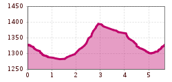
Winter hike Ködnitz-Lana-Großdorf-Ködnitz

closed
Kals am Großglockner / Glocknergruppe
Difficulty ratings: easy
Route length: 5.6 km
Duration: 2:00 h

Ködnitz-Lana-Großdorf-Ködnitz

Tour information

  • Requirement: easy
  • Length: 5.6 km
  • Duration: 2:00 h
  • Elevation uphill:185 hm
  • Elevation downhill:185 hm
Highest point1,400 m

Starting point

Glocknerhaus-Tourismusinformation Kals am Großglockner

Finishing point

Glocknerhaus-Tourismusinformation Kals am Großglockner
  • Fitness level 2 / 6
  • Technique 2 / 6

Features

  • Circular route
  • Suitable for families

Best time of year

  • January
  • February
  • March
  • April
  • May
  • June
  • July
  • August
  • September
  • October
  • November
  • December

Trail condition

partly snow and partly paved road

Equipment

Winterboots with good shoe sole and hiking poles.
Source: Nationalparkregion Hohe Tauern Osttirol

Description

An easy hike to the pittoresk village of Großdorf. Family friendly.

Nearby huts and mountain restaurants

More tours in the surrounding area

  • Rotenkogel

    Difficulty: difficult
    Length: 3.9 km Duration: 3:00 h Elevation uphill: 383 m
  • Lasörling 3.098m

    Difficulty: difficult
    Length: 21.9 km Duration: 12:00 h Elevation uphill: 1,940 m
  • Hike to the Venedigerhaus Innergschlöß

    Difficulty: easy
    Length: 8.5 km Duration: 2:30 h Elevation uphill: 180 m
  • Hiking tour to Lasörlinghütte 2.350m

    Difficulty: medium
    Length: 14.6 km Duration: 7:10 h Elevation uphill: 1,080 m
  • Hike to Kalser Tauernhaus

    Difficulty: medium
    Length: 12.2 km Duration: 4:00 h Elevation uphill: 244 m
  • Badener Hütte

    Difficulty: difficult
    Length: 23.2 km Duration: 11:30 h Elevation uphill: 1,750 m
  • Venediger altitude trail

    Difficulty: difficult
    Length: 55.5 km Duration: 27:00 h Elevation uphill: 3,915 m
  • Lasörling altitude trail

    Difficulty: medium
    Length: 57.0 km Duration: 25:00 h Elevation uphill: 3,740 m
  • Figerhorn

    Difficulty: difficult
    Length: 6.5 km Duration: 6:00 h Elevation uphill: 807 m
  • Umbal waterfalls nature force trail

    Difficulty: easy
    Length: 5.8 km Duration: 2:30 h Elevation uphill: 250 m
  • Muhs panorama trail

    Difficulty: medium
    Length: 15.2 km Duration: 6:00 h Elevation uphill: 1,090 m
  • Hike to Neuen Reichenberger Hütte

    Difficulty: medium
    Length: 9.1 km Duration: 9:00 h Elevation uphill: 1,210 m
  • Hiking tour to Neue Sajathütte 2.600m

    Difficulty: medium
    Length: 10.3 km Duration: 6:50 h Elevation uphill: 1,080 m
  • Lucknerhaus - Stüdlhütte

    Difficulty: medium
    Length: 9.3 km Duration: 5:30 h Elevation uphill: 862 m
  • Böses Weibl

    Difficulty: difficult
    Length: 14.1 km Duration: 8:00 h Elevation uphill: 1,193 m
Newsletter

The mountain is calling? So does our newsletter!

In our monthly newsletter we reveal the best holiday tips for Tyrol.