Mountain hikes River Beach Loop

Oberndorf in Tirol / Kitzbüheler Alpen
Difficulty ratings: easy
Route length: 2.6 km
Duration: 0:45 h

Small round with river experience in Oberndorf in Tirol

Tour information

  • Requirement: easy
  • Length: 2.6 km
  • Duration: 0:45 h
  • Elevation uphill:23 hm
  • Elevation downhill:23 hm
Highest point775 m

Starting point

Oberndorf - parking lot Penzing

Finishing point

Oberndorf - parking lot Penzing
  • Fitness level 2 / 6
  • Technique 1 / 6

Features

  • Circular route
  • Suitable for families

Best time of year

  • January
  • February
  • March
  • April
  • May
  • June
  • July
  • August
  • September
  • October
  • November
  • December

Trail condition

Gravel, asphalt

Equipment

- outdoor clothing
- sturdy shoes
- Sufficient food and drinks
- First aid kit
- Mobile phone with full battery & charger
- Hiking map & guide literature
- GPS device or download the GPS data to your mobile phone if necessary
- Sun protection (sunglasses, sun cream, cap)
- Rain protection
- Cash
Source: Kitzbüheler Alpen - St. Johann in Tirol

Description

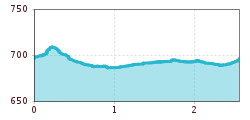
Start at the Penzing parking lot in Oberndorf. Follow the Penzingweg, which turns into the Römerweg. Now the direction leads you to the train stop Wiesenschwang, where you come down to the river Kitzbüheler Ache. Take a relaxed walk next to the rushing river. At the underpass you come back to the Römerweg, which takes you back to the starting point.

Getting here

  • Arrival by public transport


    Postbus 4000 getting off at station: Oberndorf i.T. Ort
    Zug 201 Giselabahn getting off at station: Oberndorf i. T. Bahnhof

    Bus and traintimes: 
    kitzalps.cc/mobilef

  • Parking

    Oberndorf in Tirol free parking lot Penzing

More tours in the surrounding area

  • Bichlachrunde

    Difficulty: easy
    Length: 10.5 km Duration: 3:30 h Elevation uphill: 295 m
  • Eifersbacher Wasserfall

    Difficulty: medium
    Length: 5.9 km Duration: 2:30 h Elevation uphill: 241 m
  • Alpine Outdoor Gallery

    Difficulty: easy
    Length: 3.4 km Duration: 1:00 h Elevation uphill: 117 m
  • Scenic River Trail Großache

    Difficulty: easy
    Length: 14.3 km Duration: 3:30 h Elevation uphill: 20 m
  • Kaiserbachtal - Feldberg - Stripsenjoch

    Difficulty: medium
    Length: 21.0 km Duration: 9:00 h Elevation uphill: 1,170 m
  • Eagle Walk Stage 01: St. Johann in Tirol - Gaudeamushütte

    Difficulty: medium
    Length: 13.0 km Duration: 5:00 h Elevation uphill: 1,060 m
  • Wilder-Kaiser-Steig - Detour

    Difficulty: difficult
    Length: 33.0 km Duration: 16:49 h Elevation uphill: 2,311 m
  • Schnackler Adventure Trail

    Difficulty: easy
    Length: 2.0 km Duration: 0:45 h Elevation uphill: 130 m
  • Angerer Alm

    Difficulty: medium
    Length: 5.7 km Duration: 2:45 h Elevation uphill: 652 m
Newsletter

The mountain is calling? So does our newsletter!

In our monthly newsletter we reveal the best holiday tips for Tyrol.