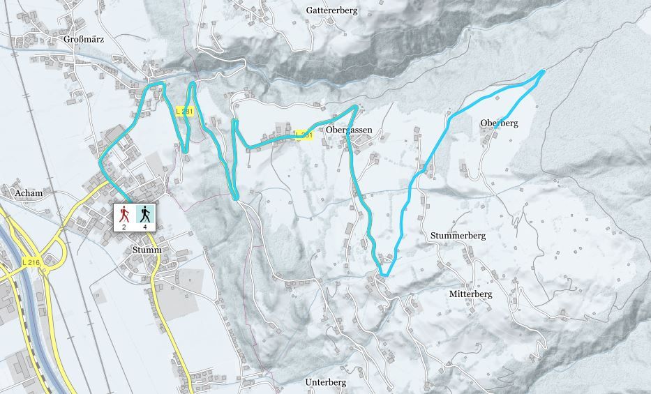
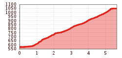
Open interactive mapOpen this POI on the interactive mapElevation profileStumm - Gasthof Tannenalm.gpx
DescriptionFrom the Stumm community hall take the road past the Gasthof Märzenklamm. From here, walk along the road and follow signs to Tannenalm.
Hochfügen - Kleiner Gilfert (2388m) Walk no. 27Difficulty: medium Length: 14.4 km Duration: 6:00 h Elevation uphill: 925 m See trailSee trail: Hochfügen - Kleiner Gilfert (2388m) Walk no. 27
Mountain station Spieljochbahn - Hochfügen Difficulty: medium Length: 12.2 km Duration: 4:00 h Elevation uphill: 270 m See trailSee trail: Mountain station Spieljochbahn - Hochfügen
Hamberg (2095m) from the Gasthof Almluft (Trail No. 37)Difficulty: medium Length: 9.4 km Duration: 4:45 h Elevation uphill: 865 m See trailSee trail: Hamberg (2095m) from the Gasthof Almluft (Trail No. 37)
Circular Hike at the KellerjochDifficulty: medium Length: 7.7 km Duration: 4:30 h Elevation uphill: 580 m See trailSee trail: Circular Hike at the Kellerjoch
Nature Trail and Bird Nature TrailDifficulty: medium Length: 6.5 km Duration: 2:00 h Elevation uphill: 250 m See trailSee trail: Nature Trail and Bird Nature Trail
Give feedback for a chance to win a special holiday experience!Click here for the surveyClick here for the survey