Cross-country skiing trail Hinterkaiser-Höflinger Trail

closed
St. Johann in Tirol
Difficulty ratings: difficult
Route length: 13.3 km

You'll work up a sweat on this long, challenging loop, that's for sure. And you will be amazed by the panorama. You can only find out for yourself whether you can complete the whole route.

We recommend because:

  • Long, difficult loop at the foot of the Niederkaiser with magnificent views of the Kaiser mountains and Hohe Salve
  • gentle start, followed by a long, challenging ascent
  • refreshments available at Gasthof Rummlerhof

Tour information

  • Requirement: difficult
  • Length: 13.3 km
  • Elevation uphill:174 hm
Highest point782 m

Starting point

St. Johann in Tirol - Koasastadion

Finishing point

St. Johann in Tirol - Koasastadion

Styles

Skating / Classic

Features

  • Tyrolean cross-country specialists
  • Fitness level 6 / 6
  • Technique 6 / 6
Source: Kitzbüheler Alpen - St. Johann in Tirol

Weather

Today

clear sky
2°C/-9°C
5 km/h
Snow depth
Now: 0 cm,
Next snowfall: 05. Dec 2025
Go to weather forecast

Description

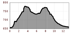
The trail starts at the Koasastadion and leads via Broatleitn to Schwentling, continuing uphill via Gasteig and Stall to Rummlerhof. There turn right and run through the Windwehen moor into the forest down to the Granderhöfe farms. Then a loop leads over the Granderkrien before returning to the Rummlerhof via the Granderhöfe. From there, the route continues via Rettenbach and Weitau back to Koasastadion.

The trail is prepared for skaters and classic skiers.

Nearby huts and mountain restaurants

Getting here

  • Arrival by public transport

    Getting off: Steinlechnerplatz - just a few minutes walking distance to the Koasa Stadion

    Bus- & traintimes and the Skibus timetable:
    kitzalps.cc/mobile
     

  • Parking

    Free of charge parking at the Koasa Stadion

Nearby cross-country skiing trails

Newsletter

The mountain is calling? So does our newsletter!

In our monthly newsletter we reveal the best holiday tips for Tyrol.