
Opening hours:Open today
Place:Walchsee
:Restaurant, Tavern:vegetarian
Path No. 16
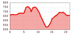
Start at the information office Walchsee, from there follow the local road to the Schwemm observation tower and then along the Moarhof golf course to Rettenschöss. At the junction, drive straight ahead towards Ritzgraben/Wildbichl. Keep left at the Niederndorferberg junction (fire station) and drive down the hill to the main road. Turn left there and take the next street on the right (bridge). From there follow the road to GH Lederer, take the left, follow the street across the Buchberg and then the road to Durchholzen. (In the district Asching you can reach the Aschinger Alm via a gravel path and get to Durchholzen via the middle station). Before the bus stop Amberg keep right and take the Seestraße back to Walchsee to the village centre.
Bicycles are not allowed on public transport. Bicycles are allowed on buses with bicycle trailers.
Parking at the starting point in Rettenschöss.


Andi Frank (247).jpg")
")

")


Erwin Haiden, bikeboard.at.jpg")

-min.jpg")


