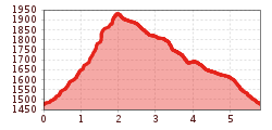
Mountain hikes Gehrner Berg RW

Steeg im Lechtal / Allgäuer Alpen
Difficulty ratings: medium
Route length: 5.8 km

Panoramic and challenging hike.

Tour information

  • Requirement: medium
  • Length: 5.8 km
  • Elevation uphill:440 hm
  • Elevation downhill:440 hm

Starting point

Obergehren

Finishing point

Obergehren

Features

  • Circular route

Best time of year

  • January
  • February
  • March
  • April
  • May
  • June
  • July
  • August
  • September
  • October
  • November
  • December

Trail condition

Asphalt, forest path, hiking path

Equipment

Good equipment is essential for your hike. The following items should definitely be in your rucksack: - Food and drink - Functional clothing for rain, wind and cold - A change of clothes - Sun protection - First aid kit - Mobile phone with a full battery (Euro emergency number 112) - Hiking map or GPS - Hiking poles Nevertheless, the following applies: light luggage is also easier to carry, so you should not weigh down your rucksack with unnecessary ballast. In addition, your hiking equipment should of course also be adapted to your particular hiking tour.
Source: Lechtal-Reutte

Description

From Obergehren, follow the hiking trail up the Gehrner Berg. Shortly before the "summit", turn left for a short distance and you will reach the southernmost German border stone. 

The way back takes you along the Gehrner Berg, constantly "changing borders", to the Schrofenpass and back to the starting point in Obergehren.

More tours in the surrounding area

Newsletter

The mountain is calling? So does our newsletter!

In our monthly newsletter we reveal the best holiday tips for Tyrol.