Arrival by public transport
From the end of June to the end of September Side valley cab
Fantastic hike with some climbing passages.

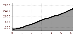
From the parking lot below the "Landgasthof Adler", walk across the Hornbach stream and a cow pasture into the forest. Here you follow a very narrow path through dense vegetation further and further uphill. You cross a wide forest path a few more times, but always turn off into the forest. After crossing the forest path one last time, your path becomes wider and more clearly recognizable. After about 2 hours, you will reach the Kaufbeurer Haus.
From here, head south, continuing behind the house in the direction of Bretterspitze. Climb up over a long, steep scree field and then keep left to reach the Schwärzer Scharte. From here, all you have to do is follow the ridge to the summit.
Climb back down the same path for about 400 meters to the scree field, keeping to the right in the direction of Urbeleskarspitze. The entrance to the summit trail is a little difficult to find, but is fairly well marked further up. From here, the terrain becomes very steep and you mainly move forward by climbing slightly. Once you have reached the Urbeleskarspitze, you have a wonderful panoramic view of the Lechtal valley.
The descent is via the same route as the ascent. First back to the Kaufbeurer Haus and from there through the forest back to the parking lot.
From the end of June to the end of September Side valley cab
Parking lot at the town hall