Mountain hikes Middlestation Hopfgarten - Laiming - Hacha - Hopfgarten

Hopfgarten im Brixental / Kitzbüheler Alpen
Difficulty ratings: medium
Route length: 7.9 km
Duration: 2:00 h

Middlestation Hopfgarten - Laiming - Hacha - Hopfgarten

Tour information

  • Requirement: medium
  • Length: 7.9 km
  • Duration: 2:00 h
  • Elevation uphill:120 hm
  • Elevation downhill:670 hm
Highest point1,279 m

Starting point

Middle station Hopfgarten

Finishing point

cenrre Hopfgarten
  • Fitness level 3 / 6
  • Technique 3 / 6

Features

  • Suitable for families

Best time of year

  • January
  • February
  • March
  • April
  • May
  • June
  • July
  • August
  • September
  • October
  • November
  • December

Trail condition

Asphalt, forest trail, footpath

Equipment

outdoor clothing Sturdy shoes sufficient food and water First aid kit Mobile phone with full battery & charger Hiking map & guide literature Possibly a GPS device or download the GPS data to your mobile phone Sun protection (sunglasses, sunscreen & cap) Rainwear & cash
Source: Kitzbüheler Alpen Region Hohe Salve

Description

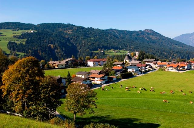
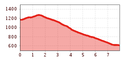
Starting point of this hike is the middle station Hopfgarten. From there, follow the signs in the direction of Itter (no. 65). At the junction "Schornwald" keep to the left and follow trail no. 67/68, past the "Schorn" farm and the "Füllenstein" alpine pasture. Through the forest you reach the farm Hofbichl, which is located in the municipal area of Itter (no. 68). From there you hike to the district Schlossblick, where you turn left in the direction of Hacha and follow the signposting no. 2 to Hopfgarten.
You return to the starting point via the market center of Hopfgarten.

Getting here

  • Arrival by public transport

    bus: Hopfgarten Berglift
    train: Hopfgarten Berglift

    Guest card = travel ticket - bus & train included! 
    Online timetables:

    www.vvt.at
    www.oebb.at

  • Parking

    free parking at the P3 Wasserfeld car park 
    cable car car park: free parking with lift ticket

More tours in the surrounding area

  • Schafsiedel

    Difficulty: medium
    Length: 15.6 km Duration: 6:45 h Elevation uphill: 1,280 m
Newsletter

The mountain is calling? So does our newsletter!

In our monthly newsletter we reveal the best holiday tips for Tyrol.