Lechweg section: Vorderhornbach - Stanzach

Vorderhornbach / Allgäuer Alpen
Difficulty ratings: easy
Route length: 3.0 km
Duration: 0:45 h

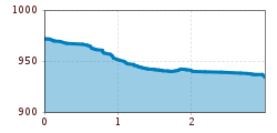
In just under an hour you walk on an easy hiking trail from Vorderhornbach to Stanzach.

Tour information

  • Requirement: easy
  • Length: 3.0 km
  • Duration: 0:45 h
  • Elevation downhill:36 hm
Highest point974 m

Starting point

Vorderhornbach

Finishing point

Stanzach
  • Fitness level 1 / 6
  • Technique 1 / 6

Features

  • Suitable for families
  • suitable for pushchairs

Best time of year

  • January
  • February
  • March
  • April
  • May
  • June
  • July
  • August
  • September
  • October
  • November
  • December

Trail condition

forest path

Equipment

Good equipment is essential for your hike. The following items should definitely be in your rucksack: - Food and drink - Functional clothing for rain, wind and cold - A change of clothes - Sun protection - First aid kit - Mobile phone with a full battery (Euro emergency number 112) - Hiking map or GPS - Hiking poles Nevertheless, the following applies: light luggage is also easier to carry, so you should not weigh down your rucksack with unnecessary ballast. In addition, your hiking equipment should of course also be adapted to your particular hiking tour.
Source: Lechtal-Reutte

Description

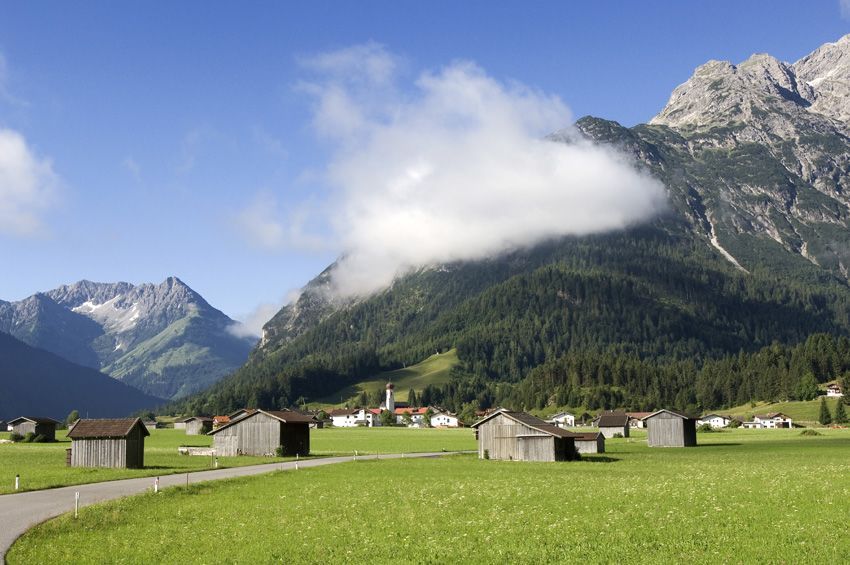
Walk along the flowering meadows to the Lech.
Shortly before the Lech bridge, still on Vorderhornbach territory, a short detour to the left from the road to Stanzach takes you up to the Baichlstein. After about 45 minutes of walking, you will reach a vantage point with a great panoramic view of Vorderhornbach and the Lechzopf downstream.

Getting here

  • Arrival by public transport

    Regional bus stop Vorderhornbach village

  • Parking

    Parking lot at the town hall, free of charge

More tours in the surrounding area

Newsletter

The mountain is calling? So does our newsletter!

In our monthly newsletter we reveal the best holiday tips for Tyrol.