Arrival by public transport
Bus stop Schwendt Dorf Line 4000
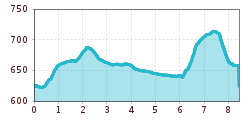
Weg Nr.
From the village center of Schwendt in the direction of Kössen, left at the Stelzerhof, downhill into the Aschental and down to the E-Werk, uphill to the Gasteigbauern. Continue left in the direction of Mitterstätthof. Uphill to Ellmerer, then left following the cycle path through Kohlental to Lederer. Before the bridge along the Kohlebach back to Mühlau, up a short climb, then left along the footpath back to the center.
Bus stop Schwendt Dorf Line 4000
Car park opposite Schwendterwirt in Schwendt village centre
.JPG")

.jpeg")

