Trail running Summit hike Hohe Salve

Söll / Kitzbüheler Alpen
Route length: 18.0 km
Duration: 7:30 h

The route – stunningly beautiful & challenging
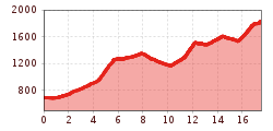
Tour information

  • Length: 18.0 km
  • Duration: 7:30 h
  • Elevation uphill:1,410 hm
  • Elevation downhill:282 hm
Highest point1,825 m

Starting point

Hiking starting point Tourist Info, Söll (689 m)

Finishing point

Hiking starting point Tourist Info, Söll (689 m)
  • Fitness level 3 / 6
  • Technique 3 / 6

Best time of year

  • January
  • February
  • March
  • April
  • May
  • June
  • July
  • August
  • September
  • October
  • November
  • December

Equipment

trail running shoes, comfortable, breathable clothing, poss. lightweight rucksack with water bottle and snacks
Source: Wilder Kaiser

Description

From Söll over the dam walls to Filzalmsee lake, continuing along the Kaisermarathon route, past Hexenwasser, around the Rigi – and then: the final meters of elevation gain to the summit. For hiking enthusiasts, leisurely walkers, and anyone who wants to hike their way to summit bliss.

Getting here

  • Arrival by public transport

    KaiserJet/Postbus stop “Söll Dorf”. More information at: www.wilderkaiser.info

  • Parking

    West Pölven public car park, Söll (689 m) – free

More tours in the surrounding area

Newsletter

The mountain is calling? So does our newsletter!

In our monthly newsletter we reveal the best holiday tips for Tyrol.