Arrival by public transport
From Steinach railway station take bus line 4146 to Gschnitz and then get off at the beginning of the village.
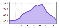
Over the Truna waterfalls, over two holes, downhill along the Martairbach. Two summits can be collected: the Rötenspitze (+240 metres in altitude) and the Muttenkopf (+300 m). Then the tour already scratches the 2000-metre altitude mark!
From the car park in the direction of Trins, St. Magdalena. A forest path leads almost level for 1.5km through the forest. Shortly before the start of the alpine meadows, another forest path turns off to the right (towards the Truna waterfalls). After another kilometre, turn half-left again, after 800m the path narrows to a trail, just before the waterfalls. 100m after crossing the Truna stream, take a sharp right, from there steeply uphill to a wide forest road, then it is no longer difficult to the Truna hut. Now follow the signposts to the Trunaalm and the Trunajoch.
From the Trunajoch in the direction of Muttenjoch westwards, after 500m the trail to the right can be used to visit the Rötenspitze (2481m). A detour to the Muttenkopf (2638m) is possible directly from the Muttenjoch. From the Muttenjoch, the trail goes steeply downhill on a technical trail northwards to the Wildgrube. From the Martairalm, the trail more or less follows the Martairbach stream. Shortly after the Kaserle hunting lodge at an altitude of 1530 metres, the right-hand path to the St. Magdalena snack station can be chosen. There the trail runner can regenerate appropriately. The way back to the starting point takes less than 30 min, follow the signs to Gschnitz, the fastest way leads on the orthographically right side of the Martairbach first comfortably descending and then at 1320 metres altitude running half-left steeply downhill to Gschnitz.
From Steinach railway station take bus line 4146 to Gschnitz and then get off at the beginning of the village.
Parking lot St. Magdalena
