Snowshoe hike Steinrastl

Obertilliach / Gailtaler Alpen
Difficulty ratings: medium
Route length: 6.2 km

Steinrastl

Tour information

  • Requirement: medium
  • Length: 6.2 km
  • Elevation uphill:740 hm
Highest point2,167 m

Starting point

Flatsch

Finishing point

Steinrastl
  • Fitness level 3 / 6
  • Technique 3 / 6

Best time of year

  • January
  • February
  • March
  • April
  • May
  • June
  • July
  • August
  • September
  • October
  • November
  • December
Source: Hochpustertal

Description

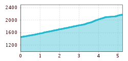
From the hamlet of Flatsch via a woodland trail in a few hairpin bends up to Schwarzmoos. The route becomes somewhat steeper from there, proceeding via lovely mountain pastureland up to the Steinrastl.

Getting here

  • Arrival by public transport

    Mit dem Bus bis zur Haltestelle "Untertilliach Winkl"

Newsletter

The mountain is calling? So does our newsletter!

In our monthly newsletter we reveal the best holiday tips for Tyrol.