Arrival by public transport
St. Jodok railway station with S-Bahn connection every 30 min from Innsbruck/Brenner [exact timetables at www.vvt.at]. Free use of the bus with the Wipptal Guest Card!
Entry tour into the Schmirntal, can also be done as a small round tour.
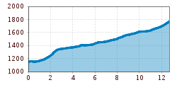
The tour connects the Wipptal with Schmirn and the single trail 5033 & 5029 Tuxerjoch and can also be ridden as a small round tour via the hamlet of Rohrach. The starting point is Stafflach in the main valley, as well as the St. Jodok railway stop. From there, the trail leads left along the church through the hamlet of Leite along the old Schmirnerstraße. After 1.5km, in the Oberleite area, you can take the path via Rohrach or continue straight ahead along the Schmirnbach stream. In the district of Aue, both paths meet again and continue to join the Schmirner-Landesstraße.
St. Jodok railway station with S-Bahn connection every 30 min from Innsbruck/Brenner [exact timetables at www.vvt.at]. Free use of the bus with the Wipptal Guest Card!
P4 Waldfestplatz Trins [car park subject to charges]


")
