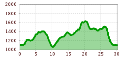
Open interactive mapOpen this POI on the interactive mapElevation profiledownload2020_trail run distance_30km_1.500Hm.gpx
Sonnenalm © Sonnenalm SonnenalmOpening hours:Open todayPlace:Grän:Alpine pasture / hut / mountain restaurantsee restaurant detailssee restaurant details: Sonnenalm
BannwaldseerundeDifficulty:mediumLength:95.4 kmDuration:3:45 hElevation uphill:591 mGo to biketourGo to biketour: Bannwaldseerunde
Blick über den Vilsalpsee © Tannheimer Tal Along the Vilsalpsee to the Bergacht WaterfallDifficulty:mediumLength:6.5 kmDuration:1:30 hElevation uphill:99 mSee trailSee trail: Along the Vilsalpsee to the Bergacht Waterfall
Der Traualpsee © Outdooractive Redaktion Three-lake route (awarded the Tyrolean Hiking Trail Seal of Quality)Difficulty:mediumLength:14.6 kmDuration:4:41 hElevation uphill:387 mSee trailSee trail: Three-lake route (awarded the Tyrolean Hiking Trail Seal of Quality)
Am Ponten auf über 2000 m. © Projekt Grenzgänger Grenzgänger - Hochalpiner Etappenwandersteig im AllgäuDifficulty:difficultLength:85.1 kmDuration:35:00 hElevation uphill:6,805 mSee trailSee trail: Grenzgänger - Hochalpiner Etappenwandersteig im Allgäu
Wegweiser an der Oberen Halde © Tannheimer Tal SchönkahlerDifficulty:mediumLength:12.4 kmDuration:5:30 hElevation uphill:798 mSee trailSee trail: Schönkahler
Wandern im Tannheimer Tal © Tannheimer Tal Circular hiking trail Tannheimer Tal Route No. 1Difficulty:difficultLength:43.2 kmDuration:10:00 hElevation uphill:698 mSee trailSee trail: Circular hiking trail Tannheimer Tal Route No. 1
Im Naturschutzgebiet Vilsalpsee © Tannheimer Tal Vilsalpsee loop trailDifficulty:mediumLength:13.4 kmDuration:2:45 hElevation uphill:173 mGo to Cross-country skiing trailGo to Cross-country skiing trail: Vilsalpsee loop trail
Am Zirleseck. © Projekt Grenzgänger Grenzgänger Stage 1 - Bschießer, Ponten, Zirleseck and Willersalpe - HintersteinDifficulty:mediumLength:13.0 kmDuration:7:00 hElevation uphill:1,054 mSee trailSee trail: Grenzgänger Stage 1 - Bschießer, Ponten, Zirleseck and Willersalpe - Hinterstein
Sonnenalm © Tannheimer Tal Gräner Höhenweg circular hike (awarded the Tyrolean Mountain Trail quality seal)Difficulty:difficultLength:12.8 kmDuration:5:20 hElevation uphill:934 mSee trailSee trail: Gräner Höhenweg circular hike (awarded the Tyrolean Mountain Trail quality seal)
Gravelbike Tour - gravel.tirol © Dominik Somweber Gravelbike TourDifficulty:difficultLength:54.0 kmDuration:6:00 hElevation uphill:1,675 mGo to biketourGo to biketour: Gravelbike Tour
Give feedback for a chance to win a special holiday experience!Click here for the surveyClick here for the survey