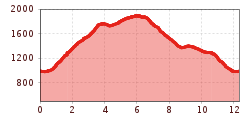
Open interactive mapOpen this POI on the interactive mapElevation profileMountain hike: Hochalmweg Ginzling.gpx
Mountain hike: Zillergrund - Valentins KapelleDifficulty: medium Length: 3.2 km Duration: 2:30 h Elevation uphill: 390 m See trailSee trail: Mountain hike: Zillergrund - Valentins Kapelle
Stage Berliner Höhenweg (Zillertal Runde): Kasseler Hütte - EdelhütteDifficulty: difficult Length: 13.0 km Duration: 9:00 h Elevation uphill: 800 m See trailSee trail: Stage Berliner Höhenweg (Zillertal Runde): Kasseler Hütte - Edelhütte
Stage of the Berliner Höhenweg (Zillertal Runde): Greizer Hütte - Kasseler HütteDifficulty: difficult Length: 9.8 km Duration: 6:00 h Elevation uphill: 650 m See trailSee trail: Stage of the Berliner Höhenweg (Zillertal Runde): Greizer Hütte - Kasseler Hütte
Stage of the Berliner Höhenweg (Zillertal Runde): Berliner Hütte - Greizer HütteDifficulty: difficult Length: 10.2 km Duration: 6:30 h Elevation uphill: 1,200 m See trailSee trail: Stage of the Berliner Höhenweg (Zillertal Runde): Berliner Hütte - Greizer Hütte
Circular & themed hike: "GenießerRundWeg" at Mount AhornDifficulty: easy Length: 2.0 km Duration: 0:45 h Elevation uphill: 70 m See trailSee trail: Circular & themed hike: "GenießerRundWeg" at Mount Ahorn
Brandberger KolmDifficulty: difficult Length: 13.7 km Duration: 7:30 h Elevation uphill: 1,600 m See trailSee trail: Brandberger Kolm
Give feedback for a chance to win a special holiday experience!Click here for the surveyClick here for the survey

 Kasseler Hütte - Edelhütte")
 Greizer Hütte - Kasseler Hütte")
 Berliner Hütte - Greizer Hütte")


