Arrival by public transport
KaiserJet stop "Söll Kreisverkehr - Steig B" or Postbus stop "Söll Kreisverkehr"
More information at: www.wilderkaiser.info/mobility
Natur Parkour

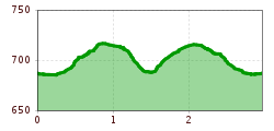
From the sports field, the first section of the route leads evenly uphill to the Sonnbichl district, past the Hotel Alpenpanorama at the intersection on the left and up a narrow path into the Schnapfl Forest. After a few meters in the forest, walk along the path on the right at the intersection. Past the first stations of the Nature Parkour, walk straight on at the next intersection at station four until the path splits again and you turn left and continue downhill towards the Moorsee. Along the edge of the forest, walking along the narrow gravel path, you can now see the bog lake on your left side. The path then branches off to the right onto the path newly built in 2024, on which the other fitness stations 11-13 are located. Once you have arrived at the upper end of the path, turn right, immediately after that turn left to get back on the path of nature Parkour. From here you can walk the same way back to the sports field.
KaiserJet stop "Söll Kreisverkehr - Steig B" or Postbus stop "Söll Kreisverkehr"
More information at: www.wilderkaiser.info/mobility
Public car park East Wilder Kaiser, Söll - free of charge