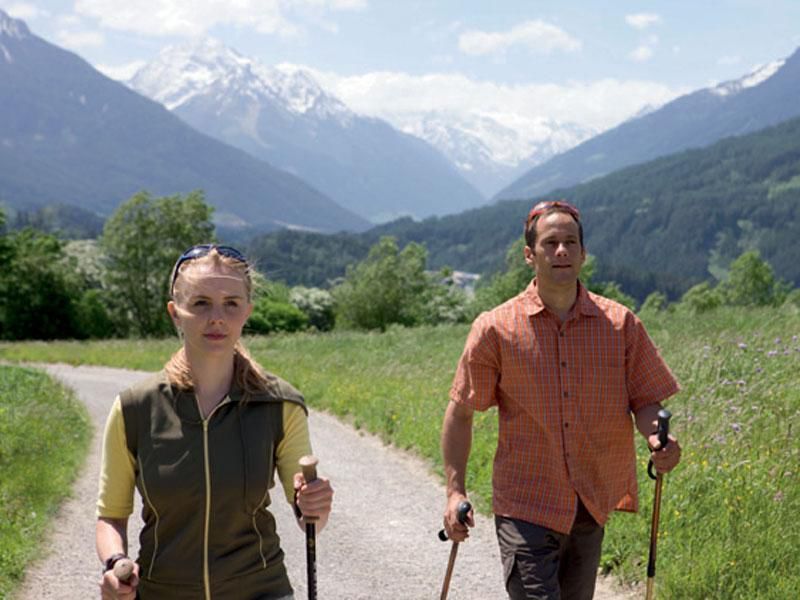
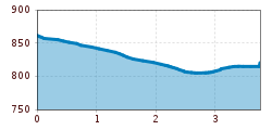
DescriptionA simple and comfortable Nordic-walking route through the fields in Götzens with beautiful views of the mountains.
Eagle Walk Stage 14: Innsbruck - Solsteinhaus LodgeDifficulty: medium Length: 7.0 km Duration: 3:00 h Elevation uphill: 940 m See trailSee trail: Eagle Walk Stage 14: Innsbruck - Solsteinhaus Lodge
Eagle Walk Stage 13: Innsbruck - Zirbenweg Trail - InnsbruckDifficulty: medium Length: 8.0 km Duration: 2:30 h Elevation uphill: 300 m See trailSee trail: Eagle Walk Stage 13: Innsbruck - Zirbenweg Trail - Innsbruck
Eagle Walk Stage 15: Solsteinhaus Lodge - Leutasch/AhrnDifficulty: medium Length: 20.0 km Duration: 6:30 h Elevation uphill: 870 m See trailSee trail: Eagle Walk Stage 15: Solsteinhaus Lodge - Leutasch/Ahrn
Biketour Tillfussalm alpine hutDifficulty: easy Length: 9.6 km Duration: 1:20 h Elevation uphill: 174 m Go to biketourGo to biketour: Biketour Tillfussalm alpine hut
Stage 3: From Mösern to Wettersteinhütte – Tyrol’s 1. Winter Multi-day HikeOpening hours: open Difficulty: medium Length: 14.0 km Duration: 6:00 h Elevation uphill: 718 m Go to winter hikeGo to winter hike: Stage 3: From Mösern to Wettersteinhütte – Tyrol’s 1. Winter Multi-day Hike
Summit hike Salfainssee - Schaflegerkogel (2,405 m) - Kemater Alm mountain hutDifficulty: medium Length: 14.8 km Duration: 7:00 h Elevation uphill: 1,029 m See trailSee trail: Summit hike Salfainssee - Schaflegerkogel (2,405 m) - Kemater Alm mountain hut
Bergdoktor-Winter Hiking TrailDifficulty: easy Length: 2.1 km Duration: 0:45 h Elevation uphill: 40 m Go to winter hikeGo to winter hike: Bergdoktor-Winter Hiking Trail
Götzner Almweg (516)Difficulty: difficult Length: 3.7 km Duration: 1:30 h Elevation uphill: 590 m Go to biketourGo to biketour: Götzner Almweg (516)
JuifenalmDifficulty: easy Length: 9.5 km Duration: 4:18 h Elevation uphill: 585 m See trailSee trail: Juifenalm
Solsteinhaus mountain hut (Alpenverein route 213)Difficulty: medium Length: 13.6 km Duration: 6:22 h Elevation uphill: 876 m See trailSee trail: Solsteinhaus mountain hut (Alpenverein route 213)
The Zirbenweg trailDifficulty: easy Length: 7.0 km Duration: 2:30 h Elevation uphill: 200 m See trailSee trail: The Zirbenweg trail
St. Sigmund - Pforzheimer Hütte mountain hut (145)Difficulty: medium Length: 14.1 km Duration: 5:00 h Elevation uphill: 781 m See trailSee trail: St. Sigmund - Pforzheimer Hütte mountain hut (145)
Hike through the SchlossbachklammDifficulty: easy Length: 12.2 km Duration: 4:30 h Elevation uphill: 488 m See trailSee trail: Hike through the Schlossbachklamm
W1: Winter Circular Hike Seefeld-Mösern-WildmoosOpening hours: open Difficulty: medium Length: 13.0 km Duration: 3:30 h Elevation uphill: 247 m Go to winter hikeGo to winter hike: W1: Winter Circular Hike Seefeld-Mösern-Wildmoos
BrunschkopfDifficulty: medium Length: 12.7 km Duration: 4:00 h Elevation uphill: 382 m See trailSee trail: Brunschkopf
Hike to the Gaistalalm & Tillfussalm alpine hutDifficulty: easy Length: 9.7 km Duration: 3:00 h Elevation uphill: 229 m See trailSee trail: Hike to the Gaistalalm & Tillfussalm alpine hut
The Chainless OneDifficulty: easy Length: 7.6 km Duration: 0:10 h Go to biketourGo to biketour: The Chainless One
The First OneDifficulty: medium Length: 2.4 km Duration: 0:15 h Go to biketourGo to biketour: The First One
The Rough OneDifficulty: difficult Length: 2.0 km Duration: 0:10 h Go to biketourGo to biketour: The Rough One
Muttereralm - Saile (Nockspitze)Difficulty: difficult Length: 7.5 km Duration: 4:00 h Elevation uphill: 789 m See trailSee trail: Muttereralm - Saile (Nockspitze)
The Sellrain Valley Mountain Hut Tour: stage 1Difficulty: medium Length: 9.3 km Duration: 3:30 h Elevation uphill: 1,101 m See trailSee trail: The Sellrain Valley Mountain Hut Tour: stage 1
The Sellrain Valley Mountain Hut Tour: stage 3Difficulty: difficult Length: 6.9 km Duration: 5:00 h Elevation uphill: 770 m See trailSee trail: The Sellrain Valley Mountain Hut Tour: stage 3
Give feedback for a chance to win a special holiday experience!Click here for the surveyClick here for the survey


.jpg")
.jpg")


_WaLogo.jpg")


.jpg")


