
Difficulty:
medium
Length:
7.0 km
Duration:
3:00 h
Elevation uphill:
940 m
Ridge walk in the Fotschertal Valley

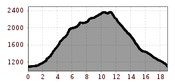
This tour starts in the Tanneben district and leads over glorious alpine meadows to the dilapidated Schmalzgrubenalm mountain hut. From there, the hike continues through the woods, emerging from the forest shortly before the Salfeinssee lake. When you come to the lake, you can enjoy breathtaking views of the Inn Valley and stunning reflections of the Kalkkögel mountains. The route then continues south along the ridge between the Fotscher Valley and the Senders Valley, leading over four peaks along the way: Grieskogel (2,168 m), Breitschwemmkogel (2,264 m), Angerbergkopf (2,400 m) and Schaflegerkogel (2,504 m). From the Schaflegerkogel, the route leads back via the Furggesalm mountain hut and the Alpengasthof Bergheim alpine guesthouse, before finally following the forest road back along the Fotscher Valley to the starting point.
Hikers must be in good shape, have high fitness levels and demonstrate excellent stamina for this tour!


.jpg")
.jpg")


_WaLogo.jpg")


.jpg")


