
Opening hours:Open today
Place:Längenfeld
:Alpine pasture / hut / mountain restaurant
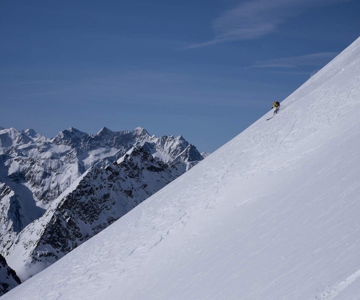
AMBERGER HUT -> Sulztalferner -> Pockkar -> HINTERER DAUNKOPF
Safety notice
Please pay attention to the current snow and avalanche report for the coming days: https://lawinen.report/bulletin/latest
Avalanche danger scale
1 (LOW) An avalanche release is only possible with a major additional load on very few, extreme steep slopes. No spontaneous avalanches (so-called slides) are expected. Generally safe conditions.
2 (MODERATE) Avalanche release is likely with major additional load especially on the indicated steep slopes. Larger avalanches are not expected. The snow cover is generally well consolidated except on some steep slopes. Careful route choice on the indicated steep slopes and exposures.
3 (CONSIDERABLE) Avalanche release is already likely with a small additional load especially on the indicated steep slopes. Occasionally some medium, sporadically also large avalanches are possible spontaneously. The snow cover is only moderately to weakly consolidated on many steep slopes. Experience in avalanche assessment is necessary. Avoid indicated steep slopes and exposures as much as possible.
4 (HIGH) Avalanche release is possible already with a small additional load especially on the indicated steep slopes. Occasionally many medium and multiple large avalanches occur. On many steep slopes the snow cover is only weakly consolidated. Route choice limited to moderately steep terrain with attention to avalanche run-out zones. Extensive experience in avalanche assessment is necessary.
5 (VERY HIGH) Spontaneous numerous large avalanches are expected, also in moderately steep terrain. At this warning level, safe operation in ski areas is no longer possible. The snow cover is generally weakly consolidated and unstable. Avoid tours.
See also lawine.tirol.gv.at
Recommended ski touring equipment
The "normal ski touring equipment" consists of touring skis with touring bindings, telescopic poles, climbing skins, crampons, digital avalanche transceiver, avalanche shovel, avalanche probe, first aid kit and a mobile phone. A "complete glacier equipment" consists of harness, two prusik loops or ascenders of different lengths, two HMS carabiners, ice axe, crampons and a rope. A backpack with appropriate contents should be carried, including change of clothes, sun protection, cold protection, provisions and enough to drink! For hut overnight stays don't forget to bring hygiene articles and a hut sleeping bag!
Difficulty rating
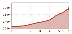
Ascent to the Amberger Hut, approx. 2h/500 meters elevation gain (overnight stay recommended). Through the Sulze up to the Sulztalferner, after the first climb keep left - ascent into the Pockkar! At its end then right over a steep step to the summit slope and to the summit cross. Wonderful view of the Stubai ski area, Sulztalferner, Hochstubai Hut!
Travel comfortably and safely by train to the Ötztal train station. The final stop or exit point is the ÖTZTAL station. Afterwards, travel conveniently and quickly by public transport or local taxi companies through the entire valley to your desired destination! The current bus schedule is available at: http://fahrplan.vvt.at
The following parking options are available in Gries:
Gries at the end of the village – paid parking
