
Opening hours:Today closed
Place:Vent
:Alpine pasture / hut / mountain restaurant
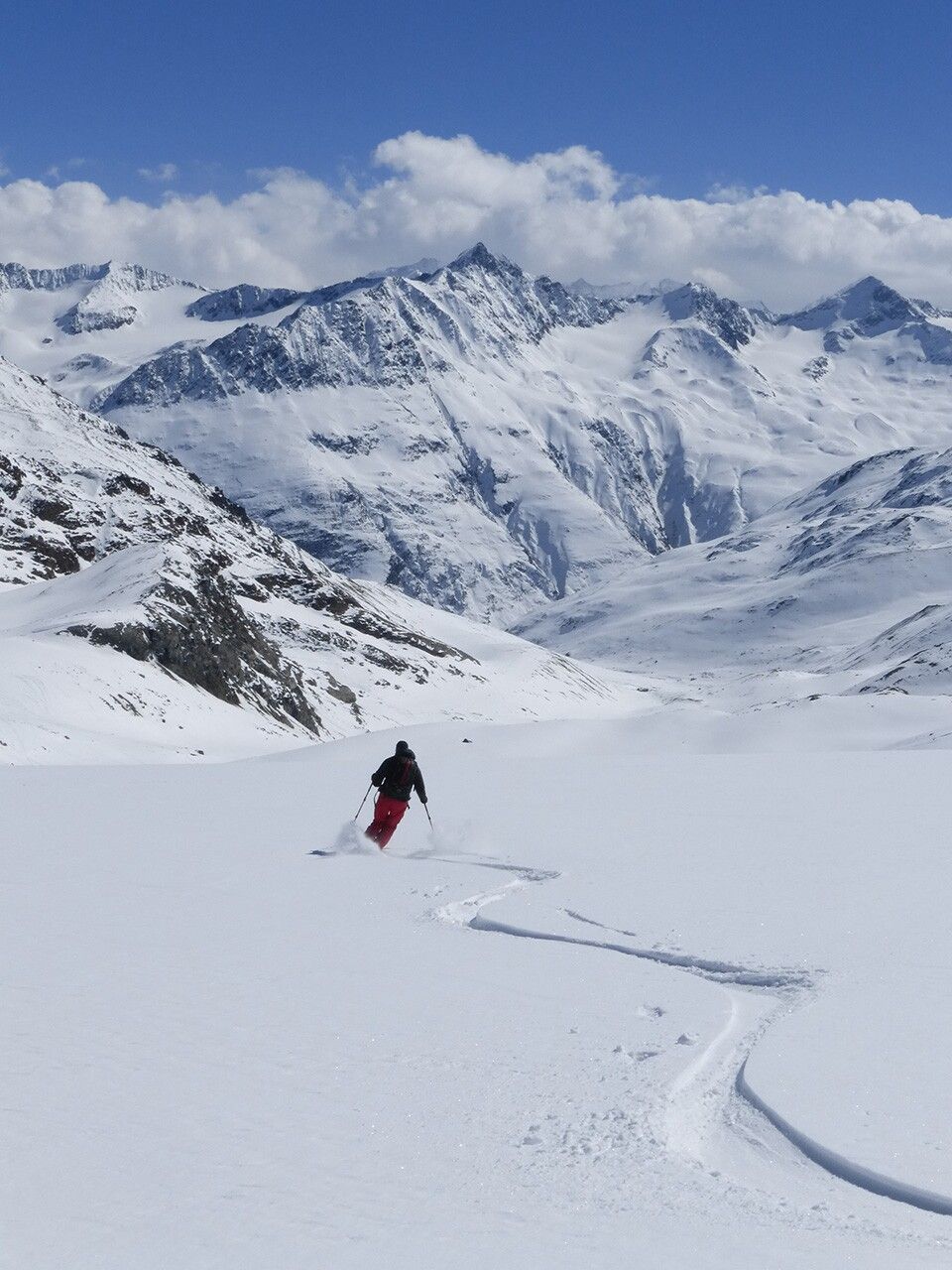
Located in the Vernagthütte tour area (closed in winter 24/25, no winter room), ski-technical difficulties with a slope steeper than 40°. Rarely climbed because the summit ascent is very steep.
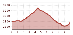
Avalanche danger scale
1 (LOW)
An avalanche release is only possible with a large additional load on very few, extreme steep slopes. No spontaneous avalanches (so-called slides) are expected. Generally safe conditions.
2 (MODERATE)
An avalanche release is probable with a large additional load mainly on the specified steep slopes. Larger avalanches are not expected. The snow cover is generally well consolidated except for some steep slopes. Careful route selection on the specified steep slopes and slope exposures.
3 (CONSIDERABLE)
An avalanche release is already probable with a small additional load mainly on the specified steep slopes. Occasionally some medium and occasionally large avalanches may occur spontaneously. The snow cover on many steep slopes is only moderately to poorly consolidated. Experience in avalanche assessment is necessary. Avoid specified steep slopes and slope exposures as much as possible.
4 (HIGH)
An avalanche release is already possible with a small additional load mainly on the specified steep slopes. Numerous medium and multiple large avalanches occur occasionally. On many steep slopes, the snow cover is weakly consolidated. Restrict route selection to moderately steep terrain and pay attention to avalanche run-out zones. Much experience in avalanche assessment is necessary.
5 (VERY HIGH)
Numerous large avalanches are expected spontaneously, also in moderately steep terrain. At this warning level, safe operation in ski areas is no longer possible. The snow cover is generally weakly consolidated and unstable. Avoid tours is recommended.
See also at lawine.tirol.gv.at
Recommended ski touring equipment
The "normal ski touring equipment" consists of touring skis with touring bindings, telescopic poles, climbing skins, crampons, digital avalanche transceiver, avalanche shovel, avalanche probe, first aid kit, and a mobile phone. A "complete glacier equipment" consists of a harness, two prusik loops or ascenders of different lengths, two HMS carabiners, an ice axe, crampons, and a rope. A backpack with appropriate contents should be carried, including spare clothing, sun protection, cold protection, food, and enough to drink! For overnight hut stays, don’t forget to take hygiene articles and a hut sleeping bag!
Difficulty rating
Although it is not the most frequented summit in the Vernagthütte tour area (closed in winter 24/25, also no winter room), the final ascent through the steep southeast flank is a notable difficulty.Ascent time: 2 h 45 minDescent time: 45 min
Travel comfortably and safely by train to the Ötztal train station. The final stop or exit point is the ÖTZTAL station. Afterwards, you can travel conveniently and quickly with public transportation or local taxi companies through the entire valley to your desired destination! The current bus schedule can be found at: http://fahrplan.vvt.at
The following parking options are available in Vent:
In front of the village and at the valley station of the chairlift (paid parking)
