Trail running Tour de Tirol | Summit hike Hohe Salve

Söll / Kitzbühel Alps
Route length: 18.0 km
Duration: 7:30 h

The route – stunningly beautiful & challenging

Tour information

  • Length: 18.0 km
  • Duration: 7:30 h
  • Elevation uphill:1,410 hm
  • Elevation downhill:280 hm
Highest point1,825 m

Starting point

Hiking starting point Tourist Info, Söll (689 m)

Finishing point

Hiking starting point Tourist Info, Söll (689 m)
  • Fitness level 3 / 6
  • Technique 3 / 6

Best time of year

  • January
  • February
  • March
  • April
  • May
  • June
  • July
  • August
  • September
  • October
  • November
  • December

Equipment

trail running shoes, comfortable, breathable clothing, poss. lightweight rucksack with water bottle and snacks
Source: TVB Wilder Kaiser

Description

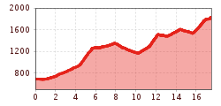
From Söll over the dam walls to Filzalmsee lake, continuing along the Kaisermarathon route, past Hexenwasser, around the Rigi – and then: the final meters of elevation gain to the summit. For hiking enthusiasts, leisurely walkers, and anyone who wants to hike their way to summit bliss.

Getting here

  • Arrival by public transport

    KaiserJet/Postbus stop “Söll Dorf”. More information at: www.wilderkaiser.info

  • Parking

    West Pölven public car park, Söll (689 m) – free

More tours in the surrounding area

Newsletter

The mountain is calling? So does our newsletter!

In our monthly newsletter we reveal the best holiday tips for Tyrol.

Oops, an error occurred! Code: 202605220417448e4161c8