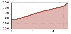
SÖLDEN GAISLACHKOGLBAHN --> Moosalm (not managed) ---> Brunnenberg --> Moosalm --> SÖLDEN GAISLACHKOGLBAHN (Brunnenbergalm closed in winter)

Please inform yourself about the path conditions and status of the respective route at Ötztal Tourism before starting the winter hiking trail.
Ötztal TourismT +43 (0) 57 200 200soelden@oetztal.com
Appropriate equipment such as breathable and weather-adapted outdoor clothing, ankle-high hiking boots, wind, rain, snow and sun protection, a hat and gloves are required for all hikes and routes.
Carrying a first aid kit, a mobile phone, and possibly a hiking map, as well as sufficient provisions for tours without catering options, is necessary.
Brunnenberg is located on the quiet side of Sölden and offers a peaceful, idyllic hike.
As a starting point, we recommend the parking lot at the Gaislachkoglbahn. From there, walk towards the campsite and cross the bridge. Then turn right and follow the path up to Moosalm. Enjoy the breathtaking panoramic view over Sölden here.
The path gently ascends further along a forest road, leading through dense forest to the Brunnenbergalm.
From Brunnenberg, a wonderful view opens up of the opposite ski mountain Gaislachkogl and the valley of Sölden.
Since the Brunnenbergalm is not managed in winter, we recommend bringing tea and a small snack to better enjoy the tranquility and the view.
Travel comfortably and safely by train to ÖTZTAL station. The final stop or exit point is ÖTZTAL station. Afterwards, you can conveniently and quickly travel by local public transport or local taxi companies through the entire valley to your desired destination.
Current bus timetables are available at: https://fahrplan.vvt.at
The following parking options are available in Sölden:
The parking spaces are subject to a fee.