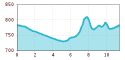
Open interactive mapOpen this POI on the interactive mapElevation profiledownloadLisa Hauser cross country ski track.gpx
Gasthof Reitherwirt © Restaurant Reitherwirt ReitherwirtOpening hours:Today closedPlace:Reith:Restaurant, Tavernsee restaurant detailssee restaurant details: Reitherwirt
Gastraum Krumma Café © Neumayr beim Krumma, Café, Brot & mehrOpening hours:Open todayPlace:Reith:cafésee restaurant detailssee restaurant details: beim Krumma, Café, Brot & mehr
Restaurant Anna Außenansicht © Anbieter Restaurant AnnaPlace:Reith:Restaurant, Tavern, cafésee restaurant detailssee restaurant details: Restaurant Anna
Gaststube Reither Streif © Anbieter Restaurant "Reither Streif"Place:Reith bei Kitzbühel:Restaurant, Tavernsee restaurant detailssee restaurant details: Restaurant "Reither Streif"
K&K Kegelbahn & Kulturhaus © Kegelnbahn Reith K&K -Bowling Alley & Culture HouseOpening hours:Open todayPlace:Reith bei Kitzbühel:Snack bar / StreetFood, Bar / Pubsee restaurant detailssee restaurant details: K&K -Bowling Alley & Culture House
Langlaufen auf der Schwalenrunde © TVB Osttirol/Berg im Bild OG Obertilliach - SchwalenrundeOpening hours:closedDifficulty:mediumLength:4.1 kmElevation uphill:21 m:Style: Skating, ClassicGo to Cross-country skiing trailGo to Cross-country skiing trail: Obertilliach - Schwalenrunde
Cross-country ski trail Stauden GschnitzOpening hours:closedDifficulty:easyLength:2.6 kmDuration:0:45 hElevation uphill:23 m:Style: ClassicGo to Cross-country skiing trailGo to Cross-country skiing trail: Cross-country ski trail Stauden Gschnitz
Cross country ski trail Schmirn KasernOpening hours:closedDifficulty:easyLength:4.0 kmDuration:0:56 hElevation uphill:38 m:Style: ClassicGo to Cross-country skiing trailGo to Cross-country skiing trail: Cross country ski trail Schmirn Kasern
Schmirn Toldern circular trailOpening hours:closedDifficulty:mediumLength:6.0 kmDuration:1:30 hElevation uphill:150 m:Style: ClassicGo to Cross-country skiing trailGo to Cross-country skiing trail: Schmirn Toldern circular trail
Steinach high-altitude cross-country ski trailOpening hours:closedDifficulty:mediumLength:4.0 kmDuration:2:00 hElevation uphill:230 m:Style: ClassicGo to Cross-country skiing trailGo to Cross-country skiing trail: Steinach high-altitude cross-country ski trail
Langlaufen am Seekirchl Seefeld © Region Seefeld, Moritz Klee A1 - Seekirchl LoipeOpening hours:closedDifficulty:easyLength:3.0 kmElevation uphill:19 m:Style: Skating, ClassicGo to Cross-country skiing trailGo to Cross-country skiing trail: A1 - Seekirchl Loipe
L.6.2 FIS Panorama Trail GaltürOpening hours:closedDifficulty:mediumLength:2.5 kmElevation uphill:53 m:Style: Skating, ClassicGo to Cross-country skiing trailGo to Cross-country skiing trail: L.6.2 FIS Panorama Trail Galtür
Langlauf © Unbekannt Cross-country trail HubenOpening hours:closedDifficulty:easyLength:1.7 kmDuration:0:19 hElevation uphill:5 m:Style: ClassicGo to Cross-country skiing trailGo to Cross-country skiing trail: Cross-country trail Huben
Der Sonne entgegen - Langlauf in Gries © Ötztal Tourismus Büro Längenfeld 9 Höhenloipe Gries - LängenfeldOpening hours:closedDifficulty:mediumLength:5.4 kmDuration:1:00 hElevation uphill:79 m:Style: ClassicGo to Cross-country skiing trailGo to Cross-country skiing trail: 9 Höhenloipe Gries - Längenfeld
loipe ochsengarten_img_7120820 © Roland Grüner Ochsengarten trailOpening hours:closedDifficulty:mediumLength:5.2 kmDuration:1:00 hElevation uphill:80 m:Style: ClassicGo to Cross-country skiing trailGo to Cross-country skiing trail: Ochsengarten trail
©-TVB-Tiroler-Oberland-Kaunertal-Die-West-Barrierefrei-Langlaufen-1 (3).jpg © Die West GmbH Adaptive cross country skiing circuit Anger at Kaunertal ValleyOpening hours:closedDifficulty:easyLength:1.0 kmElevation uphill:5 m:Style: Skating, ClassicGo to Cross-country skiing trailGo to Cross-country skiing trail: Adaptive cross country skiing circuit Anger at Kaunertal Valley
Kaiserwinkl_Winterurlaub_Langlaufen (12).JPG © www.bernhardbergmann.com Kaiserwinklloipe start Schwendt - No. 1Opening hours:closedDifficulty:difficultLength:27.0 kmDuration:2:30 hElevation uphill:560 m:Style: Skating, ClassicGo to Cross-country skiing trailGo to Cross-country skiing trail: Kaiserwinklloipe start Schwendt - No. 1
©-TVB-Tiroler-Oberland-Kaunertal-Die-West-Barrierefrei-Langlaufen-1 (19).jpg © Die West GmbH Adaptive cross-country skiing: Loch circuit in the Kaunertal ValleyOpening hours:closedDifficulty:easyLength:1.0 kmElevation uphill:10 m:Style: Skating, ClassicGo to Cross-country skiing trailGo to Cross-country skiing trail: Adaptive cross-country skiing: Loch circuit in the Kaunertal Valley
Langlaufloipe © Dominik Somweber, Naturparkregion Reutte Höfener Wiesen circuitOpening hours:closedDifficulty:easyLength:2.2 kmDuration:0:45 hElevation uphill:33 m:Style: Skating, ClassicGo to Cross-country skiing trailGo to Cross-country skiing trail: Höfener Wiesen circuit
Bichlach cross country ski trailOpening hours:closedDifficulty:difficultLength:5.9 kmElevation uphill:240 m:Style: Skating, ClassicGo to Cross-country skiing trailGo to Cross-country skiing trail: Bichlach cross country ski trail
Tauferbergloipe © Ötztal Tauferberg Trail, ÖtztalOpening hours:closedDifficulty:difficultLength:2.3 kmDuration:0:45 hElevation uphill:96 m:Style: ClassicGo to Cross-country skiing trailGo to Cross-country skiing trail: Tauferberg Trail, Ötztal
höhenloipe hochgurgl - nr. 2_img_621651938 © Ötztal Practice cross country trail Hochgurgl - No. 2Opening hours:closedDifficulty:easyLength:2.1 kmDuration:0:45 hElevation uphill:116 m:Style: ClassicGo to Cross-country skiing trailGo to Cross-country skiing trail: Practice cross country trail Hochgurgl - No. 2
Horlachtalloipe © Ötztal Horlachtal Track - Umhausen-NiederthaiOpening hours:closedDifficulty:mediumLength:3.3 kmDuration:0:49 hElevation uphill:92 m:Style: ClassicGo to Cross-country skiing trailGo to Cross-country skiing trail: Horlachtal Track - Umhausen-Niederthai
Nachtloipe © Ötztal Tourismus Büro Längenfeld 4 Night trail - LängenfeldOpening hours:closedDifficulty:mediumLength:5.2 kmDuration:1:04 hElevation uphill:2 m:Style: ClassicGo to Cross-country skiing trailGo to Cross-country skiing trail: 4 Night trail - Längenfeld
Sonnenplateauloipe © Bernd Ritschel · Cross-country skiing on the sunny plateau in NiederthaiOpening hours:closedDifficulty:easyLength:3.0 kmDuration:0:40 hElevation uphill:15 m:Style: ClassicGo to Cross-country skiing trailGo to Cross-country skiing trail: · Cross-country skiing on the sunny plateau in Niederthai
©-TVB-Tiroler-Oberland-Kaunertal-Die-West-Barrierefrei-Langlaufen-1 (15).jpg © Die West GmbH Kaser circuit: adaptive cross-country skiing trail in the Kaunertal ValleyOpening hours:closedDifficulty:easyLength:1.0 kmElevation uphill:10 m:Style: Skating, ClassicGo to Cross-country skiing trailGo to Cross-country skiing trail: Kaser circuit: adaptive cross-country skiing trail in the Kaunertal Valley
©-TVB-Tiroler-Oberland-Nauders-Rudi-Wyhlidal-Langlaufen-Mutzkopf-2018 (14).jpg © Rudi Wyhlidal MoasloipeOpening hours:closedDifficulty:mediumLength:8.0 kmElevation uphill:140 m:Style: Skating, ClassicGo to Cross-country skiing trailGo to Cross-country skiing trail: Moasloipe
©-TVB-Tiroler-Oberland-Nauders-Rudi-Wyhlidal-Langlaufen-Mutzkopf-2018 (14).jpg © Rudi Wyhlidal Langlaufroute Schwarzer SeeOpening hours:closedDifficulty:difficultLength:10.0 kmElevation uphill:200 m:Style: Skating, ClassicGo to Cross-country skiing trailGo to Cross-country skiing trail: Langlaufroute Schwarzer See
Reschenloipe Nauders - StandardloipeOpening hours:closedDifficulty:mediumLength:6.5 kmElevation uphill:25 m:Style: Skating, ClassicGo to Cross-country skiing trailGo to Cross-country skiing trail: Reschenloipe Nauders - Standardloipe
Through the Forest from Praxmar to LüsensDifficulty:mediumLength:5.0 kmDuration:0:47 hElevation uphill:54 m:Style: ClassicGo to Cross-country skiing trailGo to Cross-country skiing trail: Through the Forest from Praxmar to Lüsens
Give feedback for a chance to win a special holiday experience!Click here for the surveyClick here for the survey