
Arrival by public transport
Train stations in Germany are: Sonthofen (24 km, bus transfer) Pfronten/Ried (16 km, bus transfer) and in Austria at Reutte (24 km with bus connection).
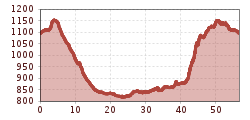
Start at the Tourism Information Office in Tannheim towards the East. At the intersection Grän/Haldensee turn left on to the Road L261 through the Engetal (valley) downhill to Pfronten to...




Every participant rides at his/her own risk.
Start at the Tourism Information Office in Tannheim towards the East. At the intersection Grän/Haldensee turn left on to the Road L261 through the Engetal (valley) downhill to Pfronten to the main street. Turn right and follow the signs to Vils/Reutte. Continue on to the Ulrichsbrücke (bridge) and turn right prior to crossing the train crossing, and ride on the road via Musau, Pflach to Reutte. Continue on the road to the train station. At the traffic circle, take the first exit right, and at the second traffic circle head straight on. At the main traffic circle in Reutte continue straight to the Lech Valley, through Lechaschau and Höfen to Weissenbach. At the traffic circle, turn right into the Tannheim Valley and back to the starting point.
Train stations in Germany are: Sonthofen (24 km, bus transfer) Pfronten/Ried (16 km, bus transfer) and in Austria at Reutte (24 km with bus connection).
The quickest and easiest and toll-free route to the Tannheim Valley by car leads via the A7 highway. Turn off at Exit "Oy-Mittelberg", turn right and follow the signs along state road B 310 heading toward Wertach/Oberjoch for ca. 15 kilometers. In Oberjoch turn left into the Tannheim Valley.
Parking near the cable car in Tannheim - chargeable


