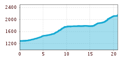
Open interactive mapOpen this POI on the interactive mapElevation profiledownloadHandbike Route Kaunertaler Gletscher.gpx
The Chainless OneDifficulty:easyLength:7.6 kmDuration:0:10 hGo to biketourGo to biketour: The Chainless One
Innsbruck to KühtaiDifficulty:difficultLength:110.0 kmDuration:4:30 hElevation uphill:1,600 mGo to biketourGo to biketour: Innsbruck to Kühtai
The First OneDifficulty:mediumLength:2.4 kmDuration:0:15 hGo to biketourGo to biketour: The First One
The Rough OneDifficulty:difficultLength:2.0 kmDuration:0:10 hGo to biketourGo to biketour: The Rough One
©-TVB-Tiroler-Oberland-Kaunertal-Daniel-Zangerl-2016-Gepatschhaus-(3).jpg © Daniel Zangerl Rolli-Wanderung GepatschhausLength:8.5 kmDuration:1:45 hElevation uphill:156 mSee trailSee trail: Rolli-Wanderung Gepatschhaus
495 - Singletrail Isskogel (495 Iss-Tough 1-2)Opening hours:openDifficulty:mediumLength:300 mDuration:0:06 hElevation uphill:9 mGo to biketourGo to biketour: 495 - Singletrail Isskogel (495 Iss-Tough 1-2)
491/492- Singletrail Isskogel (Iss-Flow 1-3)Opening hours:openDifficulty:easyLength:400 mDuration:0:08 hElevation uphill:1 mGo to biketourGo to biketour: 491/492- Singletrail Isskogel (Iss-Flow 1-3)
13 Zillertal-RadwegDifficulty:easyLength:30.5 kmDuration:2:00 hElevation uphill:125 mGo to biketourGo to biketour: 13 Zillertal-Radweg
The Neue Magdeburger Hütte - MTB route (543)Difficulty:difficultLength:16.3 kmDuration:3:24 hElevation uphill:1,001 mGo to biketourGo to biketour: The Neue Magdeburger Hütte - MTB route (543)
Oberer Gerry TrailOpening hours:openDifficulty:mediumLength:1.2 kmGo to biketourGo to biketour: Oberer Gerry Trail
Nauders, Plamort Trail_Tirol Werbung_Schels Sebastian_Nauders (1) © Tirol Werbung | Sebastian Schels Plamort TrailOpening hours:openDifficulty:Very easyLength:2.5 kmGo to biketourGo to biketour: Plamort Trail
OD Trails Oberndorf in Tirol 5.jpg © Mirja Geh OD TrailsOpening hours:openDifficulty:mediumGo to biketourGo to biketour: OD Trails
Tux - Höllensteinhütte-Grieralm-RundeDifficulty:mediumLength:12.5 kmDuration:2:30 hElevation uphill:565 mGo to biketourGo to biketour: Tux - Höllensteinhütte-Grieralm-Runde
Moostal © TVB St. Anton am Arlberg Patrick Bätz Darmstädter HütteDifficulty:difficultLength:25.5 kmDuration:4:00 hElevation uphill:1,110 mGo to biketourGo to biketour: Darmstädter Hütte
biken102_klammljoch_2019_(c)Erwin Haiden, bikeboard.at.jpg © Erwin Haiden, bikeboard.at Klammljoch - Defereggental No. 102Difficulty:mediumLength:22.0 kmDuration:3:30 hElevation uphill:946 mGo to biketourGo to biketour: Klammljoch - Defereggental No. 102
Dolomitenrundfahrt © Expa / Groder Around the Lienz DolomitesDifficulty:mediumLength:112.0 kmDuration:3:30 hElevation uphill:1,870 mGo to biketourGo to biketour: Around the Lienz Dolomites
der Weg am Ufer des Achensees ist ein tolles Handbiker Areal © Achensee Tourismus Handbike ride Maurach - AchenkirchDifficulty:mediumLength:9.0 kmDuration:1:00 hElevation uphill:35 mGo to biketourGo to biketour: Handbike ride Maurach - Achenkirch
am Seeufer entlang von Maurach nach Pertisau © Achensee Tourismus Handbike ride Achenkirch - PertisauDifficulty:mediumLength:13.5 kmDuration:1:00 hElevation uphill:35 mGo to biketourGo to biketour: Handbike ride Achenkirch - Pertisau
Das Falzthurntal wirkt aufgrund der bunten Blumenwiesen und der markanten Bergwelt sanft und schroff zugleich. © Achensee Tourismus Handbike ride Pertisau - FalzthurnalmDifficulty:difficultLength:3.3 kmDuration:1:00 hElevation uphill:105 mGo to biketourGo to biketour: Handbike ride Pertisau - Falzthurnalm
web-wilder-kaiser-bergdoktorpraxis-ellmaul-sommer2022-mathaeusgartner-2©mathaeusgartner © Mathäus Gartner Wilder Kaiser cycle route no. 14Difficulty:mediumLength:38.3 kmElevation uphill:520 mGo to biketourGo to biketour: Wilder Kaiser cycle route no. 14
Kitzbüheler Horn, Tour Nr. 4Length:10.3 kmDuration:1:30 hElevation uphill:950 mGo to biketourGo to biketour: Kitzbüheler Horn, Tour Nr. 4
Lakata Trail © bikeboard/Roland Kachelhauser Alban Lakata Trail No. 142Difficulty:mediumLength:2.0 kmDuration:0:20 hElevation uphill:10 mGo to biketourGo to biketour: Alban Lakata Trail No. 142
Frommestrail (1).jpg © (c) Serfaus-Fiss-Ladis Marketing GmbH_Raphael Pöham Frommestrail 7077Opening hours:openDifficulty:mediumLength:9.6 kmElevation uphill:12 mGo to biketourGo to biketour: Frommestrail 7077
Komperdell Tour © © Serfaus-Fiss-Ladis Marketing GmbH Komperdell Tour 761Difficulty:mediumLength:17.4 kmDuration:1:30 hElevation uphill:650 mGo to biketourGo to biketour: Komperdell Tour 761
Singletrail Kals © Miriam Raneburger Gornerwald Trail No. 139Difficulty:difficultLength:2.3 kmDuration:0:30 hGo to biketourGo to biketour: Gornerwald Trail No. 139
Give feedback for a chance to win a special holiday experience!Click here for the surveyClick here for the survey


.jpg")


Andi Frank (247).jpg")

")

-min.jpg")

Erwin Haiden, bikeboard.at.jpg")


.jpg")


