
Arrival by public transport
Train stations in Germany are: Sonthofen (24 km, bus transfer) Pfronten/Ried (16 km, bus transfer) and in Austria at Reutte (24 km with bus connection)
Start at the Tourism Information Office in Tannheim towards the East. At the intersection Grän/Haldensee turn left on to the Road L261 through the Engetal (valley) downhill to Pfronten to the main street...

Every participant rides at his/her own risk.
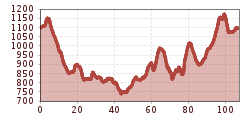
Start at the Tourism Information Office in Tannheim towards the East. At the intersection Grän/Haldensee turn left on to the Road L261 through the Engetal (valley) downhill to Pfronten to the main street. Turn left and at the center of town after a 90-degree left curve, turn right towards Füssen. Straight on at the traffic circle and follow the road to the end of the village called Eisenberg. At the intersection turn left and follow the road via Enzenstetten to Seeg. In Seeg, turn right and at the next intersection turn left in the direction of Hennenschwang/Lengenwang. In the Lengenwang town center, turn left to Albisried. Continue on the road until Wald. In the center of Wald, turn right to Leuterschach. At the end of the town head towards Engratsried, once there turn left to Oberthingau. Before you reach Oberthingau, turn left and go via Ried and Görisried to Oy-Mittelberg. At the entrance to Oy, turn right to Haag. Follow this road via Petersthal and past the Rottach See to Großdorf. Continue on to Vorderburg until Kranzegg. In the center of Kranzegg, turn left to Wertach. At the end of Wertach, at the intersection with a traffic light, turn right in direction of Oberjoch and follow the road up to the fork to Jungholz. Turn left, there is a 2.8 km acsent and a fast downhill to the Pfeiffermühle. Turn left, passing Unterjoch until you reach Oberjoch. At the crossing, turn left and follow the Bundesstraße (national road) back to the starting point in Tannheim.
Train stations in Germany are: Sonthofen (24 km, bus transfer) Pfronten/Ried (16 km, bus transfer) and in Austria at Reutte (24 km with bus connection)
The quickest and easiest and toll-free route to the Tannheim Valley by car leads via the A7 highway. Turn off at Exit "Oy-Mittelberg", turn right and follow the signs along state road B 310 heading toward Wertach/Oberjoch for ca. 15 kilometers. In Oberjoch turn left into the Tannheim Valley.
Parking near cable car in Tannheim - chargeable


