Mountain hikes Abzweigung Namloserstraße - Fallerschein - Namloser Wetterspitze - Anhalter Hütte

Stanzach / Lechtaler Alpen
Difficulty ratings: difficult
Route length: 12.4 km
Duration: 7:00 h

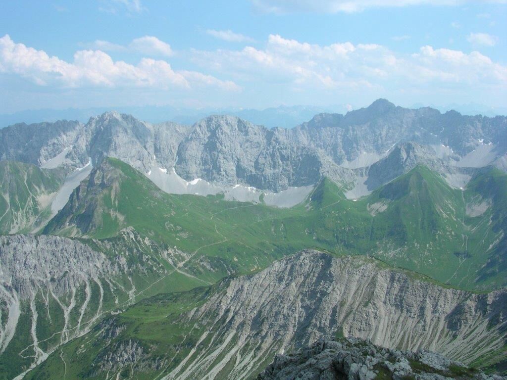
Very nice mountain tour

Tour information

  • Requirement: difficult
  • Length: 12.4 km
  • Duration: 7:00 h
  • Elevation uphill:1,505 hm
  • Elevation downhill:670 hm
Highest point2,468 m

Starting point

Parking lot at the Fallerschein junction.

Finishing point

Anhalter Hütte
  • Fitness level 5 / 6
  • Technique 4 / 6

Best time of year

  • January
  • February
  • March
  • April
  • May
  • June
  • July
  • August
  • September
  • October
  • November
  • December

Trail condition

Forest path, hiking trail

Equipment

Good equipment is essential for your hike. The following items should definitely be in your rucksack: - Food and drink - Functional clothing for rain, wind and cold - A change of clothes - Sun protection - First aid kit - Mobile phone with a full battery (Euro emergency number 112) - Hiking map or GPS - Hiking poles Nevertheless, the following applies: light luggage is also easier to carry, so you should not weigh down your rucksack with unnecessary ballast. In addition, your hiking equipment should of course also be adapted to your particular hiking tour.
Source: Lechtal-Reutte

Description

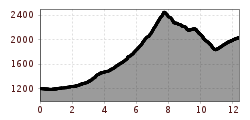
You hike along the asphalted forest path to Fallerschein.
Now a hiking trail leads you over the Gampen and along the Sommerbergbach stream steeply up to the Putzenjoch.
Now you have to climb the last 400 meters to the summit, from where the narrow mountain path takes you down to the Anhalter Höhenweg.

Nearby huts and mountain restaurants

Getting here

  • Parking

    Parking lot at the Fallerschein junction.

More tours in the surrounding area

Newsletter

The mountain is calling? So does our newsletter!

In our monthly newsletter we reveal the best holiday tips for Tyrol.