Mountain hikes Fisser Joch via Leithe Wirt to Fiss

open
Serfaus / Samnaungruppe
Difficulty ratings: medium
Route length: 11.5 km
Duration: 4:00 h

Fisser Joch via Leithe Wirt to Fiss

Tour information

  • Requirement: medium
  • Length: 11.5 km
  • Duration: 4:00 h
  • Elevation uphill:109 hm
  • Elevation downhill:1,121 hm
Highest point2,427 m

Starting point

Schönjochbahn top station

Finishing point

Fiss (Fissmed)

Features

  • Circular route
Source: Serfaus-Fiss-Ladis

Description

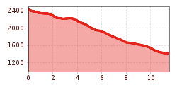
From the Fisser Joch (F087) take trail no. 20 to the Mittleren Sattelkopf (S250) and to the Komperdell (S103). Continue on Serfaus trail no. 9 and the Bifang trail no. 4 (S034) with great views above the village along to the forest trail no. 13 (S030) and on this trail to Fiss (F140), or from the Komperdell on the Panorama Genussweg (S081, Panorama Enjoyment Trail) to the Möseralm (F113).

Nearby huts and mountain restaurants

More tours in the surrounding area

  • Wild Animals Trail

    Opening hours: open
    Difficulty: easy
  • Marmot Trail

    Opening hours: open
    Difficulty: easy
    Length: 573 m Duration: 0:20 h Elevation uphill: 12 m
  • Hiking trail to the Frommes Alp

    Opening hours: open
    Difficulty: easy
    Length: 3.9 km Duration: 1:30 h Elevation uphill: 273 m
  • Six Senses trail

    Opening hours: open
    Difficulty: easy
    Length: 5.7 km Duration: 4:00 h
  • Murmeltiersteig (Marmot alpine trail)

    Opening hours: open
    Difficulty: medium
    Length: 6.9 km Duration: 3:00 h Elevation uphill: 302 m
  • Forscherpfad

    Opening hours: open
    Difficulty: easy
    Length: 3.4 km Duration: 1:30 h Elevation uphill: 219 m
  • Six Senses trail

    Opening hours: open
    Difficulty: easy
    Length: 6.5 km Duration: 4:00 h Elevation uphill: 99 m
Newsletter

The mountain is calling? So does our newsletter!

In our monthly newsletter we reveal the best holiday tips for Tyrol.