Legenden Cafe in Kitzbühel © Legenden Cafe Legenden CaféÖffnungszeiten:Heute geöffnetOrt:Kitzbühel:caféZum GastronomiebetriebZum Gastronomiebetrieb: Legenden Café
Hocheckhütte im Sommer © Kitzbühel Tourismus HocheckhütteÖffnungszeiten:Heute geöffnetOrt:Kitzbühel:Tavern, Alpine pasture / hut / mountain restaurantZum GastronomiebetriebZum Gastronomiebetrieb: Hocheckhütte
Berghaus Hochkitzbühel im Sommer © Kitzbühel Tourismus Hochkitzbühel by TomschyÖffnungszeiten:Heute geöffnetOrt:Kitzbühel:Tavern, Alpine pasture / hut / mountain restaurant, Bar / PubZum GastronomiebetriebZum Gastronomiebetrieb: Hochkitzbühel by Tomschy
Sintersbacher-Wasserfall-WGS-09942.jpg © Simon Weller Sintersbach WaterfalllSchwierigkeit:mediumLänge:9.3 kmDauer:4:00 hHöhenmeter bergauf:543 mZur WandertourZur Wandertour: Sintersbach Waterfalll
Jochberger 7-Brunnenweg (6).jpg © Kitzbühel Tourismus 7-BrunnenwegSchwierigkeit:easyLänge:10.3 kmDauer:2:30 hHöhenmeter bergauf:200 mZur WandertourZur Wandertour: 7-Brunnenweg
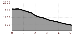
KitzTrail Streif-liveSchwierigkeit:mediumLänge:7.1 kmDauer:3:00 hHöhenmeter bergauf:23 mZur WandertourZur Wandertour: KitzTrail Streif-live
Gamsroas-WGS-01811.jpg © Simon Weller Saalkogel-Rauber-Laubkogel Nr. 87Schwierigkeit:mediumLänge:11.1 kmDauer:6:00 hHöhenmeter bergauf:947 mZur WandertourZur Wandertour: Saalkogel-Rauber-Laubkogel Nr. 87
Kitzbühler Horn Alpine flower garden (18).jpg © Kitzbühel Tourismus Alpenblumengarten (Alpine flowers garden)Schwierigkeit:easyLänge:2.0 kmDauer:1:00 hHöhenmeter bergauf:28 mZur WandertourZur Wandertour: Alpenblumengarten (Alpine flowers garden)
Kelchalm 1 © Kitzbühel Tourismus Kelchalm - Bochumer HütteSchwierigkeit:mediumLänge:13.0 kmDauer:5:00 hHöhenmeter bergauf:651 mZur WandertourZur Wandertour: Kelchalm - Bochumer Hütte
KAT Walk E 5 / E 4 © Erwin Haiden KAT Walk Compact stage 4: Scaling summits – Magnificent adventures on the Kitzbüheler HornSchwierigkeit:mediumLänge:21.0 kmDauer:8:00 hHöhenmeter bergauf:1,250 mZur WandertourZur Wandertour: KAT Walk Compact stage 4: Scaling summits – Magnificent adventures on the Kitzbüheler Horn
KAT Walk E 5 / E 4 © Erwin Haiden KAT Walk Alpine stage 5Schwierigkeit:mediumLänge:21.0 kmDauer:8:00 hHöhenmeter bergauf:1,313 mZur WandertourZur Wandertour: KAT Walk Alpine stage 5
Feedback geben und besondere Urlaubserlebnisse gewinnen!Hier geht's zur UmfrageHier geht's zur Umfrage


.jpg")


.jpg")


