Mountain hikes Salvenberg pleasure route

open
Söll / Kitzbüheler Alpen
Difficulty ratings: easy
Route length: 9.0 km
Duration: 3:15 h

Culinary hike over the Salvenberg combined with fun and games for the whole family.

Tour information

  • Requirement: easy
  • Length: 9.0 km
  • Duration: 3:15 h
  • Elevation uphill:440 hm
  • Elevation downhill:440 hm
Highest point1,170 m

Starting point

Talstation Bergbahn, Söll (725 m)

Finishing point

Talstation Bergbahn, Söll (725 m)
  • Fitness level 3 / 6
  • Technique 2 / 6

Features

  • Circular route
  • Suitable for families

Best time of year

  • January
  • February
  • March
  • April
  • May
  • June
  • July
  • August
  • September
  • October
  • November
  • December

Trail condition

The composition of the path varies between tarmac road and gravel path.

Equipment

Rucksack, sturdy hiking/mountaineering boots with anti-slip treaded soles, weather-appropriate hiking gear (breathable), a change of clothes, sun protection (sunglasses, sun cream, lip protection, headgear), waterproofs (rain jacket/poncho, pocket umbrella, rucksack protector), cold protection (hat, gloves), sufficient food and drink, hiking poles (height adjustable) if required, first aid kit incl. rescue blanket and bivouac sack, mobile phone with fully charged battery, headlamp, plastic bag for waste, hiking map, route description and information materials (GPX track), ID, insurance card, cash
Source: Wilder Kaiser

Description

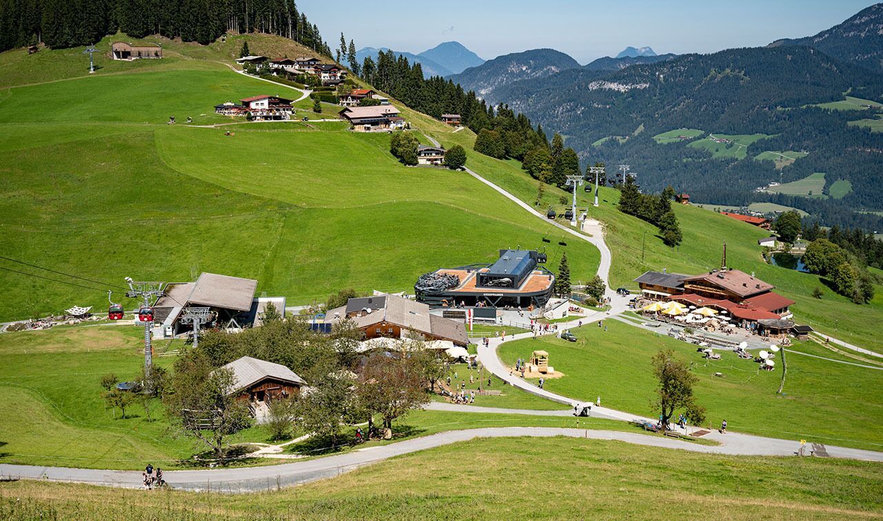
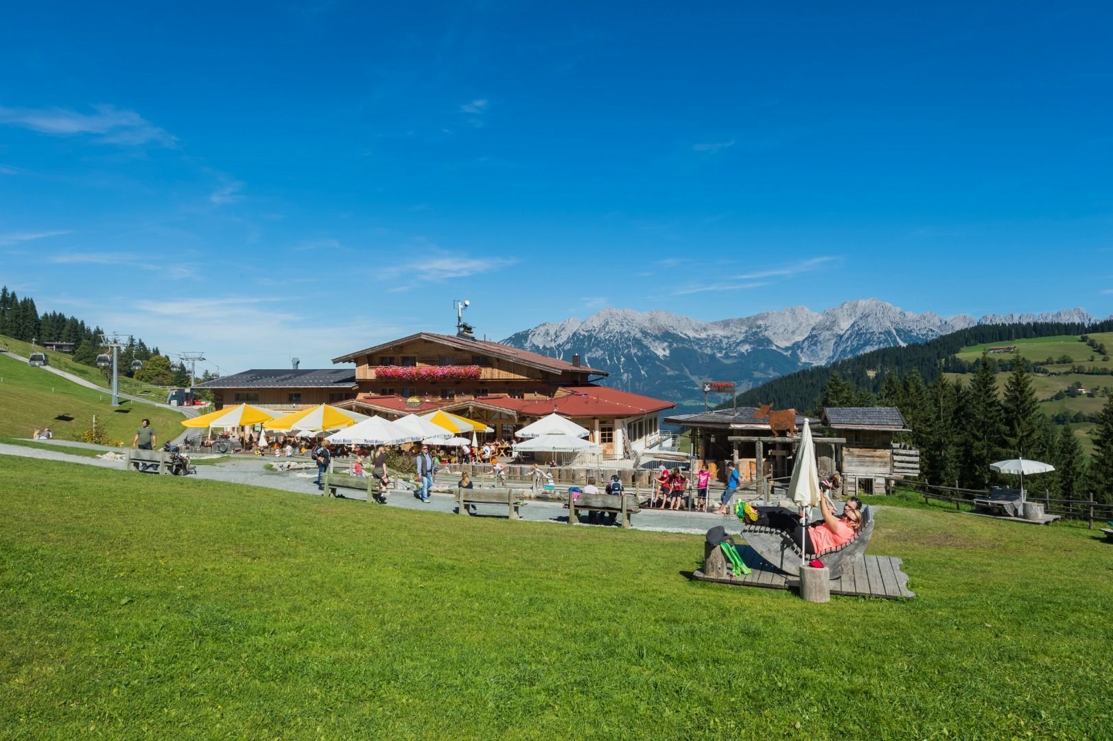
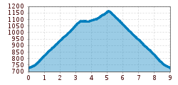
The starting point for this culinary pleasure hike over the Salvenberg is the car park at the Söll mountain railway. Walk past the valley station on the left and follow the signs to Hochsöll and Jausenstation Oberhausberg on the right through the subway. Follow the tarmac road up the Salvenberg via hairpin bends, past the Niedermühlbichler holiday farm, until you reach the Salvenmoos and Koglbauer junction. Here you follow the signpost in the direction of Stöcklalm. This is the first refreshment stop on this enjoyable tour. The tour continues through the Hexenwasser, past the large parasols and the Hochsöller pond. With a bit of luck, you might meet the witches of Söll here and join them in a little witchcraft. And as fun and games are known to make you hungry, the next opportunities for refreshments are already here. Be it for an ice cream sundae at the Alpengasthof Hochsöll or a delicious Kaiserschmarrn at the Gründlalm. From Alpengasthof Hochsöll, follow the signs in the direction of Gasthof Salvenmoos, where there is another opportunity for a culinary treat. Well fortified, you then head back down the Salvenberg and return to the starting point via the tarmac road.

Nearby huts and mountain restaurants

  • Gründlalm

    Opening hours:Open today
    Place: Söll
    : Alpine pasture / hut / mountain restaurant
  • Hochsöll

    Opening hours:Open today
    Place: Söll
    : Alpine pasture / hut / mountain restaurant
    see restaurant details: Hochsöll
  • Salvenmoos

    Opening hours:Open today
    Place: Söll
    : Alpine pasture / hut / mountain restaurant
  • Stöcklalm

    Opening hours:Open today
    Place: Söll
    : Restaurant, Alpine pasture / hut / mountain restaurant

Getting here

  • Arrival by public transport

    KaiserJet stop “Söll Gondelbahn Hochsöll – Hexenwasser”.
    More information at: www.wilderkaiser.info

  • Parking

    Parking area cable car valley station, Söll (725 m) – free

More tours in the surrounding area

  • Panoramic circuit Brandstadl–Hartkaiser

    Difficulty: easy
    Length: 6.0 km Duration: 1:50 h Elevation uphill: 170 m
  • Hochalm hike

    Difficulty: medium
    Length: 19.6 km Duration: 7:00 h Elevation uphill: 1,140 m
  • Hintere Goinger Halt summit tour

    Difficulty: difficult
    Length: 8.9 km Duration: 6:30 h Elevation uphill: 1,090 m
  • Winter walking Biedringer Platte

    Opening hours: open
    Length: 12.7 km Duration: 5:30 h Elevation uphill: 470 m
Newsletter

The mountain is calling? So does our newsletter!

In our monthly newsletter we reveal the best holiday tips for Tyrol.