.jpg")
Difficulty:
difficult
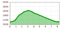
Length:
13.0 km
Duration:
7:30 h
Elevation uphill:
1,054 m
Short description:Experience nature and wildlife up close. The Usseralpe is one of the few alpine dairies.Starting from Tannheim with the 8-seater gondola to Neunerköpfle/mountain station. From the Gundhütte to Usseralpe, about 1/2 hour and back to the mountain station, about 3/4 hour. Descent with the gondola to Tannheim. Walking time about 1 1/4 hoursOn foot:Starting from Tannheim, ascent via Schmieden path to Usseralpe, about 3/4 hour. Descent via the same path back to Schmieden and Tannheim about 1 hour.Other descent option:Another option from Usseralpe is an ascent of about 1/2 hour to the saddle, then to the Upper Strindalpe, about 1/2 hour, and descent to Edenachalpe and to Haldensee about 2 hours. On the circular hiking trail back to the valley station of the gondola about 1 hour or by hiking bus from Haldensee back to Tannheim. Walking time 3-4 hoursQuality of experience: ****Recommended season:MayJuneJulyAugustSeptemberOctoberProperties:LoopScenicRefreshment stops availableFamily friendlyCableway ascent/descentSuitable for strollersDisability access

Description:
The barrier-free trails and excursion destinations selected by us also invite families and people with mobility aids to discover: they are mostly paved or well-graveled and mostly easy to navigate with strollers or wheelchairs – for some sections however a helping hand can be advantageous.
Directions:


