
Arrival by public transport
By train to Sonthofen, Pfronten/Ried or Reutte, then by bus to Tannheim.
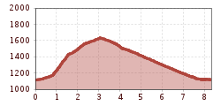
Experience nature and wildlife up close. The Usseralpe is one of the few alpine dairies. Starting from Tannheim with the 8-seater gondola to Neunerköpfle/mountain station. From the Gundhütte to Usseralpe, about 1/2 hour and back to the mountain station, about 3/4 hour. Descent with the gondola to Tannheim. Walking time about 1 1/4 hoursOn foot:Starting from Tannheim, ascent via Schmieden path to Usseralpe, about 3/4 hour. Descent via the same path back to Schmieden and Tannheim about 1 hour. Other descent option:Another option from Usseralpe is an ascent of about 1/2 hour to the saddle, then to the Upper Strindalpe, about 1/2 hour, and descent to Edenachalpe and to Haldensee about 2 hours. On the circular hiking trail back to the valley station of the gondola about 1 hour or by hiking bus from Haldensee back to Tannheim. Walking time 3-4 hours

The barrier-free trails and excursion destinations selected by us also invite families and people with mobility aids to discover: they are mostly paved or well-graveled and mostly easy to navigate with strollers or wheelchairs – for some sections however a helping hand can be advantageous.
By train to Sonthofen, Pfronten/Ried or Reutte, then by bus to Tannheim.
On the A7 motorway at the "Oy-Mittelberg" exit onto B310 towards Wertach and Oberjoch. There follow the signs "Tannheimer Tal" B199, exit Tannheim, Neunerköpfle cable car.From the Tyrol side via Reutte on B198 towards Lechtal to Weißenbach, over the Gaichtpass along B199 to the exit Tannheim, Neunerköpfle cable car.
Parking in Schmieden or parking lots in Tannheim (all paid).

