Arrival by public transport
KaiserJet stop "Söll Kreisverkehr - Steig B" or Postbus stop "Söll Kreisverkehr"
More information at: www.wilderkaiser.info/mobility
Lake circuit

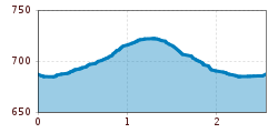
Starting from the football field, you first walk towards the fire station and then turn into the district of Gänsleit and follow the paved road. Behind the Obwaller carpentry, you then turn into a narrow path, which leads over a small wooden bridge, and then back onto the community road. You are now in the district of Bach. Follow the road until you reach the intersection after the 'Maroslhof', from there a partially unpaved path continues towards the lift parking lot of the Söll mountain railways. Upon reaching the parking lot, walk to the end towards the village center. There you will find a narrow gravel path leading towards Ahornsee. At the end of the lake, you will find a wooden bridge to your left, which leads to the Ahornsee parking lot. Then turn right to reach the Gänsleit district again. At the intersection with the community road, turn left to return to the fire station and finally to the football field.
KaiserJet stop "Söll Kreisverkehr - Steig B" or Postbus stop "Söll Kreisverkehr"
More information at: www.wilderkaiser.info/mobility
Public car park East Wilder Kaiser, Söll - free of charge