
Difficulty:difficult
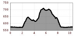
Length:7.8 kmDuration:4:45 hElevation uphill:844 m
Mühlau trail
A scenic and undulating route that leads through the district of Mühlau.
First follow the route east to the Hans-Psenner-Steg bridge. Cross the bridge and continue uphill towards the Alpine Zoo. Below Judenbichl hill, turn right and follow the path to Mühlau. The path then passes the former Kroneöl factory and the graveyard before reaching a steeper and more challenging section up to the model plane site. At the edge of the forest, the path leads left, back past the Alpine Zoo and all the way back down to the River Inn.


alexandraerhart-27.jpeg")


.jpg")

.jpg")
.jpg")
 Mirja Geh (26).jpg")


.jpg")


