
Place:
Mutters
Difficulty:
medium
St. Quirin - Rosskogel

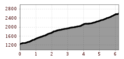
This hike starts at St. Quirin Church in Sellrain. To the west of the church, you'll find a signposted forest road that takes you directly to a trail up through the forest to Meils. A broad ridge then guides you steadily west with views of the Rosskogel mountain the whole way. The route climbs very slowly up through wonderful alpine pastures towards the summit. At an altitude of about 2,400 metres above sea level, you leave the ridge and join a path that leads up the south-facing slopes of the Rosskogel to the summit. This hike is an absolute highlight thanks to the beautiful scenery and magnificent panoramic views, especially when looking out towards Innsbruck and the Inn Valley.

.jpg")


_WaLogo.jpg")


.jpg")


.jpg")
