Mountain hikes The Sellrain Valley Mountain Hut Tour

Sellrain / Stubaier Alpen
Difficulty ratings: difficult
Route length: 84.3 km
Duration: 7 days

The circular hut tour leads through the unique mountain world of the Sellrain Alps, past crystal-clear mountain lakes and flower-filled alpine pastures. With the ascent of the Schöntalspitze, a genuine three-thousand-meter peak beckons. Overnight stays are in cozy Alpine Club huts, which ensure a great atmosphere with their excellent cuisine. Because, no matter how exhausting the stage was, a Gröstl will recharge your batteries.

Tour character

The seven-day long-distance hike is challenging and mostly follows black mountain trails. Alpine experience is therefore a prerequisite, as is surefootedness for steep, sometimes steep climbs, rope-secured passages, rocky and gravelly terrain. The approximately 7,000 meters in altitude and 84 kilometers of trail require a good level of fitness.

Tour information

  • Requirement: difficult
  • Length: 84.3 km
  • Duration: 7 days
  • Elevation uphill:5,085 hm
  • Elevation downhill:0 hm
Highest point3,008 m

Starting point

Sellrain

Finishing point

Sellrain

Features

  • Circular route
  • Multi-day hike

Best time of year

  • January
  • February
  • March
  • April
  • May
  • June
  • July
  • August
  • September
  • October
  • November
  • December
Source: Innsbruck region

Description

The "Sellrainer Hüttenrunde" is a high alpine, multi-day, circular hut hike that leads through the entire Kühtai-Sellrain Valley region. There are plenty of ways to join and enjoy the trail, which shows the full variety of the Sellrain mountains from the huge, glacier-covered granite gneiss mountains in the upper Lüsens Valley to the gentle hills around the Fotscher Valley and the mighty Acherkogel high above the Tyrolean Oberland region.

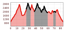
Seven days, 80 kilometres and 5,700 vertical metres – the Sellrain Valley Mountain Hut Tour is a truly special mountaineering experience.

The tour starts in Sellrain at an altitude of 900 metres above sea level and climbs right up to Schöntalspitze peak, the highest point of the tour, at an altitude of over 3,000 metres above sea level. The tour is split into seven stages and passes numerous mountain huts along the way, where you can enjoy delicious Tyrolean cuisine, rustic accommodation and rejuvenating tranquillity.

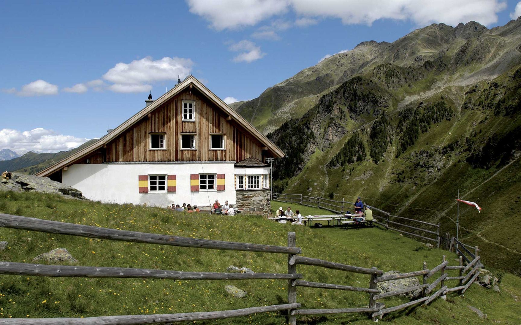
The tour stops at the following mountain huts: Potsdamer Hütte, Westfalenhaus, Pforzheimer Hütte, Schweinfurter Hütte, Bielefelder Hütte and Dortmunder Hütte. The route requires a lot of stamina and mountain experience.

Getting here

  • Arrival by public transport

    Regiobus Sellrain Valley - route 4166

More long-distance hiking trails

  • Karwendel tour

    Difficulty: difficult
    Length: 44.2 km Duration: 4 days Elevation uphill: 3,955 m
  • Wilder-Kaiser-Steig - Detour

    Difficulty: difficult
    Length: 33.0 km Duration: 16:49 h Elevation uphill: 2,311 m
  • Eagle Walk Tirol

    Difficulty: difficult
    Length: 426.0 km Duration: 33 days Elevation uphill: 30,000 m
  • Rofan tour

    Difficulty: medium
    Length: 30.5 km Duration: 4 days Elevation uphill: 1,450 m
  • Senn's WunderWanderWeg

    Opening hours: closed
    Difficulty: easy
    Length: 1.0 km Duration: 0:30 h Elevation uphill: 81 m
  • 3-Tages-Tour Wilder

    Difficulty: difficult
    Length: 11.0 km Duration: 4:51 h Elevation uphill: 1,122 m
  • 3-Tages-Tour Wilder

    Difficulty: difficult
    Length: 13.6 km Duration: 7:09 h Elevation uphill: 694 m
  • 3-day hut tour Wilder Kaiser

    Difficulty: difficult
    Length: 24.6 km Duration: 14:00 h Elevation uphill: 2,060 m
  • Two day tour - Höhenweg Zahmer Kaiser

    Opening hours: open
    Difficulty: medium
    Length: 30.0 km Duration: 13:15 h Elevation uphill: 2,100 m
  • Two days tour Wilder Kaiser

    Difficulty: difficult
    Length: 42.5 km Duration: 15:57 h Elevation uphill: 2,475 m
Newsletter

The mountain is calling? So does our newsletter!

In our monthly newsletter we reveal the best holiday tips for Tyrol.