Multi-day hikes Karwendel tour

Difficulty ratings: difficult
Route length: 44.2 km
Duration: 4 days

Challenging 3-day tour in the Karwendel mountains with 3 summit climbs, 45 km, approx. 4,000 metres of elevation gain and two overnight stays in mountain huts. Highlights: Rappenspitze, Sonnjoch, Lamsenspitze.

Tour information

  • Requirement: difficult
  • Length: 44.2 km
  • Duration: 4 days
  • Elevation uphill:3,955 hm
  • Elevation downhill:3,960 hm
Highest point2,457 m

Starting point

Pertisau, valley station of the Karwendel cable car

Finishing point

Pertisau, valley station of the Karwendel cable car
  • Fitness level 6 / 6
  • Technique 6 / 6

Features

  • Multi-day hike

Best time of year

  • January
  • February
  • March
  • April
  • May
  • June
  • July
  • August
  • September
  • October
  • November
  • December

Trail condition

hiking trail (partially secured with iron steps and a steel rope, exposed areas), hiking path, forest road, asphalt

Equipment

Sturdy boots (ankle-high hiking boots), weather appropriate clothing, enough to drink and eat. Telescopic hiking poles and a first aid kit are recommended. Hut sleeping bag. The tour requires sure-footedness and a head for heights.
Source: Achensee Tourismus

Description

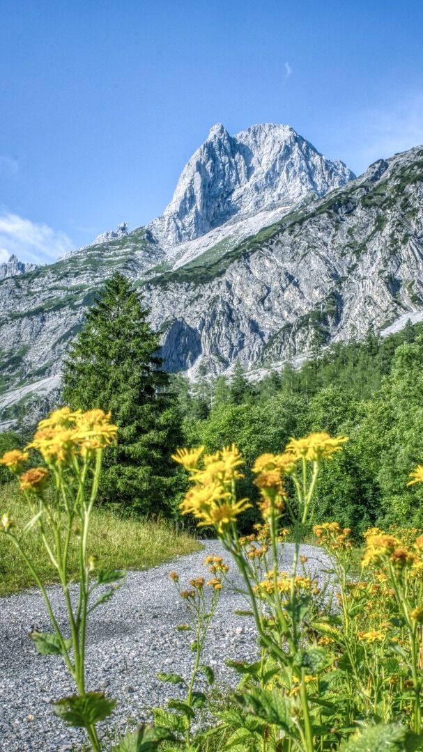
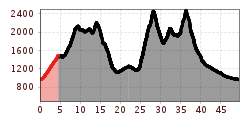
This challenging 3-day hike takes you over three striking peaks in the Karwendel mountains: Rappenspitze (2,233m), Sonnjoch (2,457m), and Lamsenspitze (2,508m). Starting and finishing in Pertisau, the route includes scenic ridges, alpine passes, and managed huts/inns for two overnight stays. Expect a total of around 45 kilometres and approx. 4,000m elevation gain.

Stage 1: From the top station of the Karwendel cable car (Zwölferkopf), follow the trail via the Bärenbadalm (refreshments available), Weißenbachsattel, Blasermahdlegg and Ochsenkopf to the Nauderer Kar, and continue to the Rappenspitze (2,233m). Descent via the Dristlalm to the Gramai Alm (1,267m, overnight stay).

Access to Stage 1 is also possible from the valley station of the Karwendel cable car via the Rodlhütte to the top station.

Stage 2: From the Gramai Alm via the Gramai Hochleger to the Sonnjoch (2,457m). Return to the Gramai Hochleger (refreshments available), continue over the Gramaisattel, the Gramaijoch and the Hahnkampl (2,082m) to the Lamsenjochhütte (1,953m, overnight stay).

Stage 3: From the Lamsenjochhütte, climb via the Lamsenscharte to the Lamsenspitze (2,508m), then descend to the Gramai Alm and continue via the Falzthurnalm back to Pertisau.

Getting here

  • Arrival by public transport

    Take the regional bus (lines 8332 or 390) to the Karwendel cable car and get off at the "Pertisau Karwendellift" stop.  

  • Parking

    Car park of the Karwendel cable car no. 1 or 2 (subject to charge)

More long-distance hiking trails

  • Arlberg Trail

    Difficulty:difficult
    Length:52.1 kmElevation uphill:4,730 m
  • EUREGIO-Marien-Weg-M3

    Difficulty:easy
    Length:179.0 kmDuration:52:17 hElevation uphill:3,190 m
  • EUREGIO-Maria-Weg-M4

    Difficulty:easy
    Length:123.0 kmDuration:36:00 hElevation uphill:2,330 m
  • EUREGIO Mary Way-M1

    Difficulty:medium
    Length:84.1 kmDuration:25:01 hElevation uphill:2,238 m
  • EUREGIO-Maria-Weg-M5

    Difficulty:easy
    Length:166.6 kmDuration:46:16 hElevation uphill:2,971 m
  • Senn's WunderWanderWeg

    Difficulty:easy
    Length:1.0 kmDuration:0:30 hElevation uphill:81 m
  • EUREGIO Marien-Weg-M6

    Difficulty:easy
    Length:12.1 kmDuration:3:38 hElevation uphill:268 m
  • Lechtaler Höhenweg

    Difficulty:difficult
    Length:84.5 kmDuration:45:00 hElevation uphill:6,773 m
  • Talweg Matrei i. O.

    Difficulty:medium
    Length:15.9 kmDuration:4:30 hElevation uphill:407 m
  • Two day tour - Höhenweg Zahmer Kaiser

    Opening hours:open
    Difficulty:medium
    Length:30.0 kmDuration:13:15 hElevation uphill:2,100 m
  • Two days tour Wilder Kaiser

    Difficulty:difficult
    Length:42.5 kmDuration:15:57 hElevation uphill:2,475 m
  • KAT WALK ALPINE

    Difficulty:medium
    Length:113.0 kmDuration:6 daysElevation uphill:6,300 m
  • Koasa Trail

    Difficulty:medium
    Length:83.0 kmDuration:5 daysElevation uphill:4,700 m
  • KAT Walk: Three Valleys Hike

    Difficulty:medium
    Length:69.0 kmDuration:30:00 hElevation uphill:3,684 m
  • 3-day hut tour Wilder Kaiser

    Difficulty:difficult
    Length:24.6 kmDuration:14:00 hElevation uphill:2,060 m
  • Karwendel High Trail

    Difficulty:difficult
    Length:70.0 kmDuration:6 daysElevation uphill:4,470 m
  • Tiroler Pilgerweg

    Difficulty:medium
    Length:220.0 kmElevation uphill:1,840 m
Newsletter

The mountain is calling? So does our newsletter!

In our monthly newsletter we reveal the best holiday tips for Tyrol.