Ansicht Stripsenjochhaus © Claudia Moritz Stripsenjoch HouseOpening hours:Open todayPlace:Ebbs:Alpine pasture / hut / mountain restaurantsee restaurant detailssee restaurant details: Stripsenjoch House
Pfandlhof Kaisertal Wandern Hütte Einkehr © Lolin Mountain inn PfandlhofOpening hours:Open todayPlace:Ebbs:Alpine pasture / hut / mountain restaurantsee restaurant detailssee restaurant details: Mountain inn Pfandlhof
Seekirchl mit Neuschnee - 29.11.2023 - Querformat.jpg © Region Seefeld Complete Route for the Seefeld High Plateau Winter Multi-day HikeOpening hours:closedDifficulty:mediumLength:65.2 kmElevation uphill:1,157 mGo to winter hikeGo to winter hike: Complete Route for the Seefeld High Plateau Winter Multi-day Hike
Antoniuskapelle im Kaisertal © Sportalpen Marketing 3-Tages-Tour WilderDifficulty:difficultLength:11.0 kmDuration:4:51 hElevation uphill:1,122 mSee trailSee trail: 3-Tages-Tour Wilder
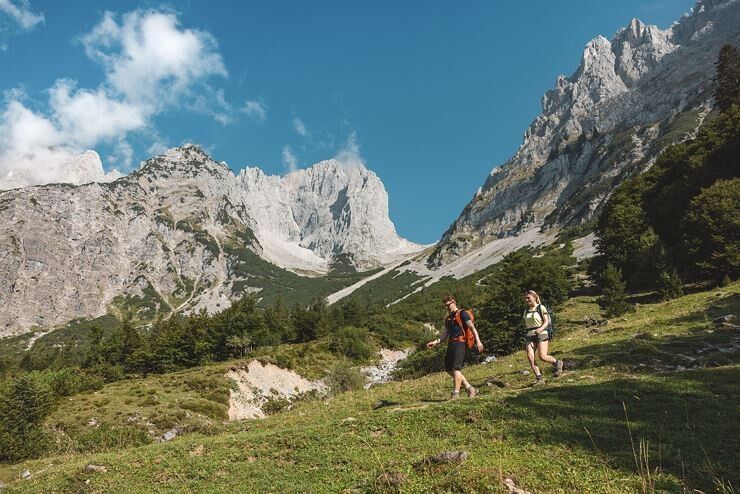
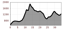
web-wandern-weitwandern-wilder-kaiser-foto-von-felbert-reiter-164©danielreiterpetervonfelbert.jpg © Daniel Reiter /Peter von Felbert 3-Tages-Tour WilderDifficulty:difficultLength:13.6 kmDuration:7:09 hElevation uphill:694 mSee trailSee trail: 3-Tages-Tour Wilder
Panorama Sölllandl_Wilder Kaiser © TVB Wilder Kaiser/Mathäus Gartner Kaiserblüte - Multi-Day Hiking ExperienceDifficulty:mediumLength:80.6 kmDuration:31:45 hElevation uphill:5,050 mSee trailSee trail: Kaiserblüte - Multi-Day Hiking Experience
Ausblick Solder © Tourismusverband Osttirol 2TälerTrailDifficulty:mediumLength:92.0 kmDuration:41:30 hElevation uphill:5,550 mSee trailSee trail: 2TälerTrail
Kircher Alm am Gailtaler Höhenweg © Schneider The Gailtal altitude trail - stages of OsttirolOpening hours:openDifficulty:mediumLength:30.9 kmDuration:13:30 hElevation uphill:1,738 mSee trailSee trail: The Gailtal altitude trail - stages of Osttirol
Museum Galerie Schloss Landeck_010 © Huber Roman Tiroler BurgenwegDifficulty:mediumLength:63.0 kmDuration:25:00 hElevation uphill:2,228 mSee trailSee trail: Tiroler Burgenweg
Lechtal Alps-Zams, Steinseehütte, from Hanauerhütte to Württemberger Haus, Adlerweg, stage 20_Tirol Werbung_Gigler Dominik_Zams (1).jpg © Gigler Dominik Eagle Walk TirolDifficulty:difficultLength:426.0 kmElevation uphill:30,000 mSee trailSee trail: Eagle Walk Tirol
Wanderer am Ostgipfel der Hohen Munde © Region Seefeld, Eva Beer Complete Route – Big 3 Multi-day Hike on Tirols HochplateauDifficulty:mediumLength:62.0 kmDuration:32:00 hElevation uphill:4,510 mSee trailSee trail: Complete Route – Big 3 Multi-day Hike on Tirols Hochplateau
Gschnitztaler Hüttenstern ALPSOLUTpictures (115).jpg © Johannes Mair // ALPSOLUT Pictures Gschnitztaler HüttensternDifficulty:mediumLength:10.8 kmDuration:4:14 hElevation uphill:538 mSee trailSee trail: Gschnitztaler Hüttenstern
Gogles Alm © Gogles Alm/Joachim E5 Konstanz - Oberstdorf - MeranDifficulty:difficultSee trailSee trail: E5 Konstanz - Oberstdorf - Meran
Gschnitztaler Hüttenstern ALPSOLUTpictures (115).jpg © Johannes Mair // ALPSOLUT Pictures Gschnitztaler HüttensternDifficulty:mediumLength:82.1 kmDuration:4:00 hElevation uphill:5,503 mSee trailSee trail: Gschnitztaler Hüttenstern
Peter Habeler RundeDifficulty:difficultLength:41.3 kmDuration:17:00 hElevation uphill:2,236 mSee trailSee trail: Peter Habeler Runde
Weitwandern Etappe 3 Winterlandschaft (1).jpg © Region Seefeld, Johannes Geyer Complete Route for the Tyrol’s 1. Winter Multi-day HikeOpening hours:closedDifficulty:mediumLength:53.0 kmDuration:15:30 hElevation uphill:1,060 mGo to winter hikeGo to winter hike: Complete Route for the Tyrol’s 1. Winter Multi-day Hike
Mountain lakes and a panoramic peak in a class of its own Difficulty:mediumLength:23.9 kmDuration:11:30 hElevation uphill:2,188 mSee trailSee trail: Mountain lakes and a panoramic peak in a class of its own
Kaiserlift Wandern Naturerlebnis Kaisergebirge © Sportalpen Marketing 2-day mountain tour Güttlersteig to SonneckDifficulty:difficultLength:15.0 kmDuration:12:30 hElevation uphill:2,330 mSee trailSee trail: 2-day mountain tour Güttlersteig to Sonneck
web-wandern-weitwandern-wilder-kaiser-foto-von-felbert-reiter-177©danielreiterpetervonfelbert.jpg © Daniel Reiter /Peter von Felbert Two days tour Wilder KaiserDifficulty:difficultLength:42.5 kmDuration:15:57 hElevation uphill:2,475 mSee trailSee trail: Two days tour Wilder Kaiser
Zireiner See Abendstimmung © Thomas Kargl 4 days - 4 summits tourDifficulty:mediumLength:54.4 kmDuration:23:00 hElevation uphill:3,408 mSee trailSee trail: 4 days - 4 summits tour
Aussichtsplattform Steinweg © Gabriele Grießenböck 3-day Family Tour AlpbachtalDifficulty:easyLength:18.3 kmDuration:7:00 hElevation uphill:998 mSee trailSee trail: 3-day Family Tour Alpbachtal
Am Ponten auf über 2000 m. © grenzgaenger-wandern.com Grenzgänger - Hochalpiner Etappenwandersteig im AllgäuDifficulty:difficultLength:85.1 kmDuration:35:00 hElevation uphill:6,805 mSee trailSee trail: Grenzgänger - Hochalpiner Etappenwandersteig im Allgäu
Salve @Region Hohe Salve - Mathäus Gartner © @Region Hohe Salve - Mathäus Gartner KAT Walk: Three Valleys HikeDifficulty:mediumLength:69.0 kmDuration:30:00 hElevation uphill:3,684 mSee trailSee trail: KAT Walk: Three Valleys Hike
Thierberg © TVB Kufsteinerland EUREGIO Marien-Weg-M7Difficulty:easyLength:50.8 kmDuration:15:20 hElevation uphill:984 mSee trailSee trail: EUREGIO Marien-Weg-M7
Koasatrail Etappe 4 Region St. Johann in Tirol - Oberndorf - Kirchdorf - Erpfendorf © Sportalpen Koasa TrailDifficulty:mediumLength:83.0 kmElevation uphill:4,700 mSee trailSee trail: Koasa Trail
Arlberg_Marketing_Arlbergtrail_WEST © West Werbeagentur GmbH Arlberg TrailDifficulty:difficultLength:52.1 kmElevation uphill:4,730 mSee trailSee trail: Arlberg Trail
Dürrenberg © Rene Paulweber / Fotostudio Rene Circular Route Around the Valley Basin | 3-Day Hiking TourDifficulty:mediumLength:32.0 kmDuration:15:00 hElevation uphill:2,459 mSee trailSee trail: Circular Route Around the Valley Basin | 3-Day Hiking Tour
Give feedback for a chance to win a special holiday experience!Click here for the surveyClick here for the survey


.jpg")

.jpg")


.jpg")


