Open interactive mapOpen this POI on the interactive mapElevation profileDownloadKAT Walk: Three Valleys Hike.gpx
Blick zum mächtigen Bergstock Guffert © Achensee Tourismus From Mountaineering Village to Mountaineering VillageDifficulty:difficultLength:26.1 kmDuration:13:00 hElevation uphill:2,440 mSee trailSee trail: From Mountaineering Village to Mountaineering Village
Jakobsweg - Osttirol StagesDifficulty:mediumLength:67.7 kmDuration:21:00 hElevation uphill:1,765 mSee trailSee trail: Jakobsweg - Osttirol Stages
Long-distance hike: Berliner Höhenweg (Zillertal Runde)Difficulty:difficultLength:71.0 kmDuration:35:00 hElevation uphill:5,300 mSee trailSee trail: Long-distance hike: Berliner Höhenweg (Zillertal Runde)
hoch-tirol-trail-abstieg-umbaltal-chl2322-c-geomarketing-christjanladurner.jpg © Geomarketing - Christjan Ladurner Hoch Tirol TrailDifficulty:difficultLength:28.9 kmDuration:12:30 hElevation uphill:1,519 mSee trailSee trail: Hoch Tirol Trail
Lechtaler Alpen-Zams, Steinseehütte, von Hanauerhütte bis Württemberger Haus, Adlerweg, Etappe 20_Tirol Werbung_Gigler Dominik_Zams (1).jpg © Gigler Dominik Eagle Walk TirolDifficulty:difficultLength:426.0 kmElevation uphill:30,000 mSee trailSee trail: Eagle Walk Tirol
Gogles Alm © Gogles Alm/Joachim E5 Konstanz - Oberstdorf - MeranDifficulty:difficultSee trailSee trail: E5 Konstanz - Oberstdorf - Meran
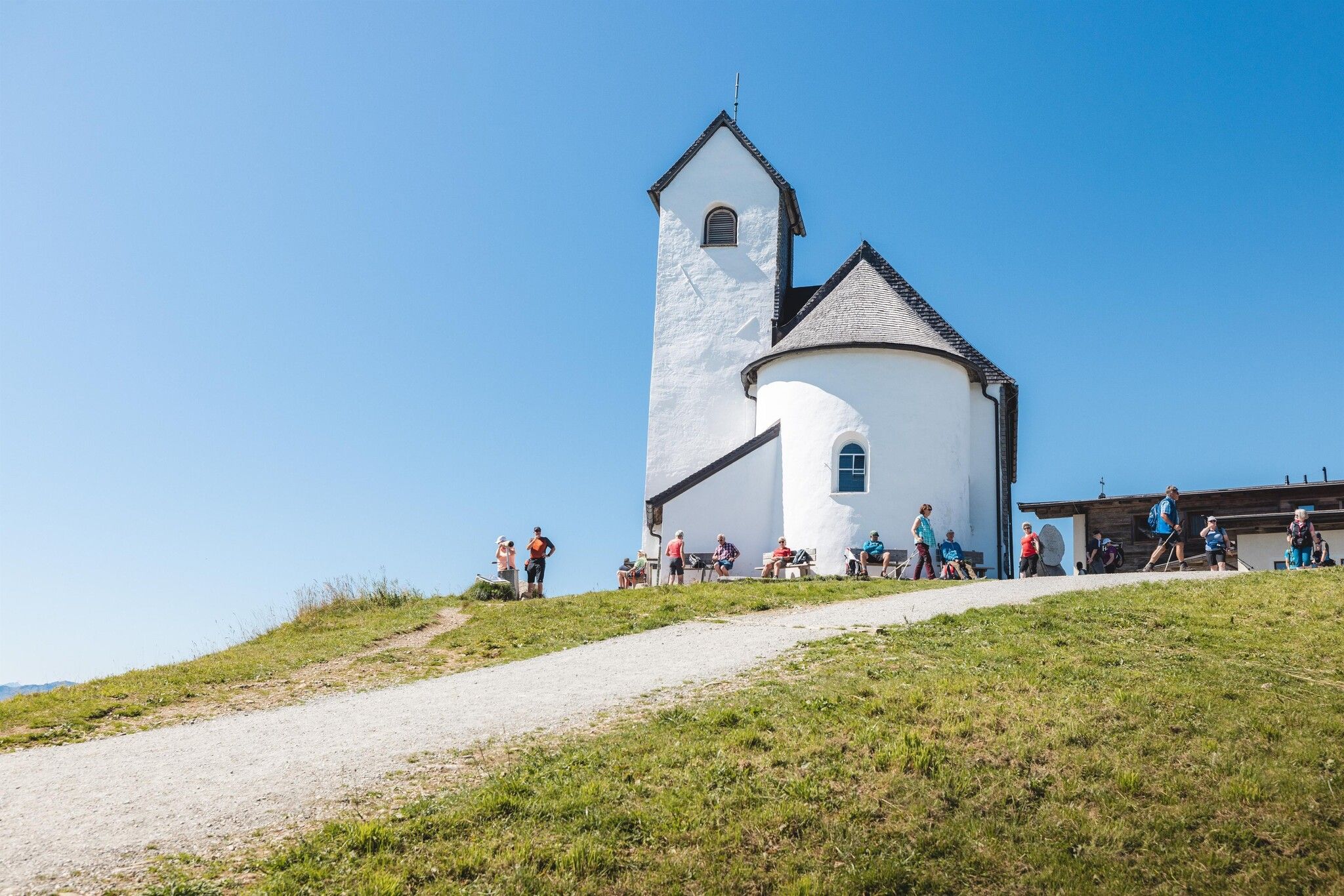
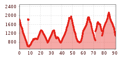
Kitzbüheler Alpen_KATwalk2018-Etappe4_Erwin Haiden07.jpg © Erwin Haiden KAT WALK ALPINEDifficulty:mediumLength:113.0 kmDuration:45:00 hElevation uphill:6,300 mSee trailSee trail: KAT WALK ALPINE
EUREGIO-Marien-Weg-M3Difficulty:easyLength:179.0 kmDuration:52:17 hElevation uphill:3,190 mSee trailSee trail: EUREGIO-Marien-Weg-M3
Thierberg Kapelle Wandern © Sportalpen Marketing EUREGIO-Maria-Weg-M4Difficulty:easyLength:123.0 kmDuration:36:00 hElevation uphill:2,330 mSee trailSee trail: EUREGIO-Maria-Weg-M4
Weitwanderung Peter Habeler Runde © Archiv TVB Mayrhofen Long-distance hike: Peter Habeler RundeDifficulty:difficultLength:56.7 kmDuration:25:00 hElevation uphill:3,705 mSee trailSee trail: Long-distance hike: Peter Habeler Runde
hubertuskapelle-ströden-c-berny-steiner.jpg © Berny Steiner Pilgerweg Prägraten a.G.Difficulty:mediumLength:33.1 kmDuration:27:00 hElevation uphill:2,793 mSee trailSee trail: Pilgerweg Prägraten a.G.
Karwendelhaus mit Bergpanorama © Region Seefeld, Miriam Mayer Karwendelmarsch 52 kmDifficulty:mediumLength:53.5 kmDuration:19:00 hElevation uphill:2,180 mSee trailSee trail: Karwendelmarsch 52 km
hintere-ochsenalm-blick-lapawitzkees-glocknergruppe-c-eva-oberhauser.jpg © Eva Oberhauser Großglockner trekDifficulty:difficultLength:86.1 kmElevation uphill:7,209 mSee trailSee trail: Großglockner trek
MaucheleWA055.jpg © TVB Pitztal/Bernd Ritschl Kaunergrat Circular Route - 5 DaysDifficulty:difficultLength:42.5 kmDuration:23:00 hElevation uphill:3,804 mSee trailSee trail: Kaunergrat Circular Route - 5 Days
Kaunergrathütte © TVB Pitztal/Roman Huber Kaunergrat Circular Route - 3 DaysDifficulty:difficultLength:22.8 kmDuration:13:00 hElevation uphill:2,650 mSee trailSee trail: Kaunergrat Circular Route - 3 Days
Naturparkhaus_mit Wanderer.JPG © TVB Pitztal Kaunergrat Circular Route - 7 DaysDifficulty:difficultLength:66.4 kmElevation uphill:5,496 mSee trailSee trail: Kaunergrat Circular Route - 7 Days
Adlerweg Logo © TVB Osttirol Adlerweg trail through OsttirolDifficulty:difficultLength:93.3 kmElevation uphill:7,101 mSee trailSee trail: Adlerweg trail through Osttirol
wanderung-grosser-zunig-wokenmeer-c-bernhard-assmair.jpg © Bernhard Aßmair Lasörling altitude trailDifficulty:mediumLength:55.4 kmDuration:25:00 hElevation uphill:3,718 mSee trailSee trail: Lasörling altitude trail
loebbentoerl-schlatenkees-sommer-2024-c-bernhard-assmair.JPG © Bernhard Aßmair Venediger altitude trailDifficulty:difficultLength:55.5 kmDuration:27:00 hElevation uphill:3,975 mSee trailSee trail: Venediger altitude trail
The Sellrain Valley Mountain Hut TourDifficulty:difficultLength:84.3 kmDuration:40:00 hElevation uphill:5,085 mSee trailSee trail: The Sellrain Valley Mountain Hut Tour
Gschnitztaler Hüttenstern ALPSOLUTpictures (115).jpg © Johannes Mair // ALPSOLUT Pictures Gschnitztaler HüttensternDifficulty:mediumLength:10.8 kmDuration:4:14 hElevation uphill:538 mSee trailSee trail: Gschnitztaler Hüttenstern
Zireiner See Abendstimmung © Thomas Kargl 4 days - 4 summits tourDifficulty:mediumLength:54.4 kmDuration:23:00 hElevation uphill:3,408 mSee trailSee trail: 4 days - 4 summits tour
Wildseeloderhaus © Toni Niederwieser WaiWi - from Waidring to the WildseeloderDifficulty:mediumLength:50.0 kmDuration:24:00 hElevation uphill:3,200 mSee trailSee trail: WaiWi - from Waidring to the Wildseeloder
The Tyrolean section of The Way of St. James through InnsbruckDifficulty:easyLength:81.4 kmDuration:21:00 hElevation uphill:900 mSee trailSee trail: The Tyrolean section of The Way of St. James through Innsbruck
Give feedback for a chance to win a special holiday experience!Click here for the surveyClick here for the survey


")

.jpg")


.jpg")


