Riffelseehütte © TVB Pitztal/Severin Wegener Riffelseehütte (2,293 m)Opening hours:Today closedPlace:St. Leonhard im Pitztal:Alpine pasture / hut / mountain restaurantsee restaurant detailssee restaurant details: Riffelseehütte (2,293 m)
Taschachhaus © TVB Pitztal/Severin Wegener Taschachhaus (2,434 m)Opening hours:Today closedPlace:St. Leonhard im Pitztal:Alpine pasture / hut / mountain restaurantsee restaurant detailssee restaurant details: Taschachhaus (2,434 m)
Kaunergrathütte © TVB Pitztal/Roman Huber Kaunergrathütte (2,817 m)Opening hours:Today closedPlace:St. Leonhard im Pitztal:Alpine pasture / hut / mountain restaurantsee restaurant detailssee restaurant details: Kaunergrathütte (2,817 m)
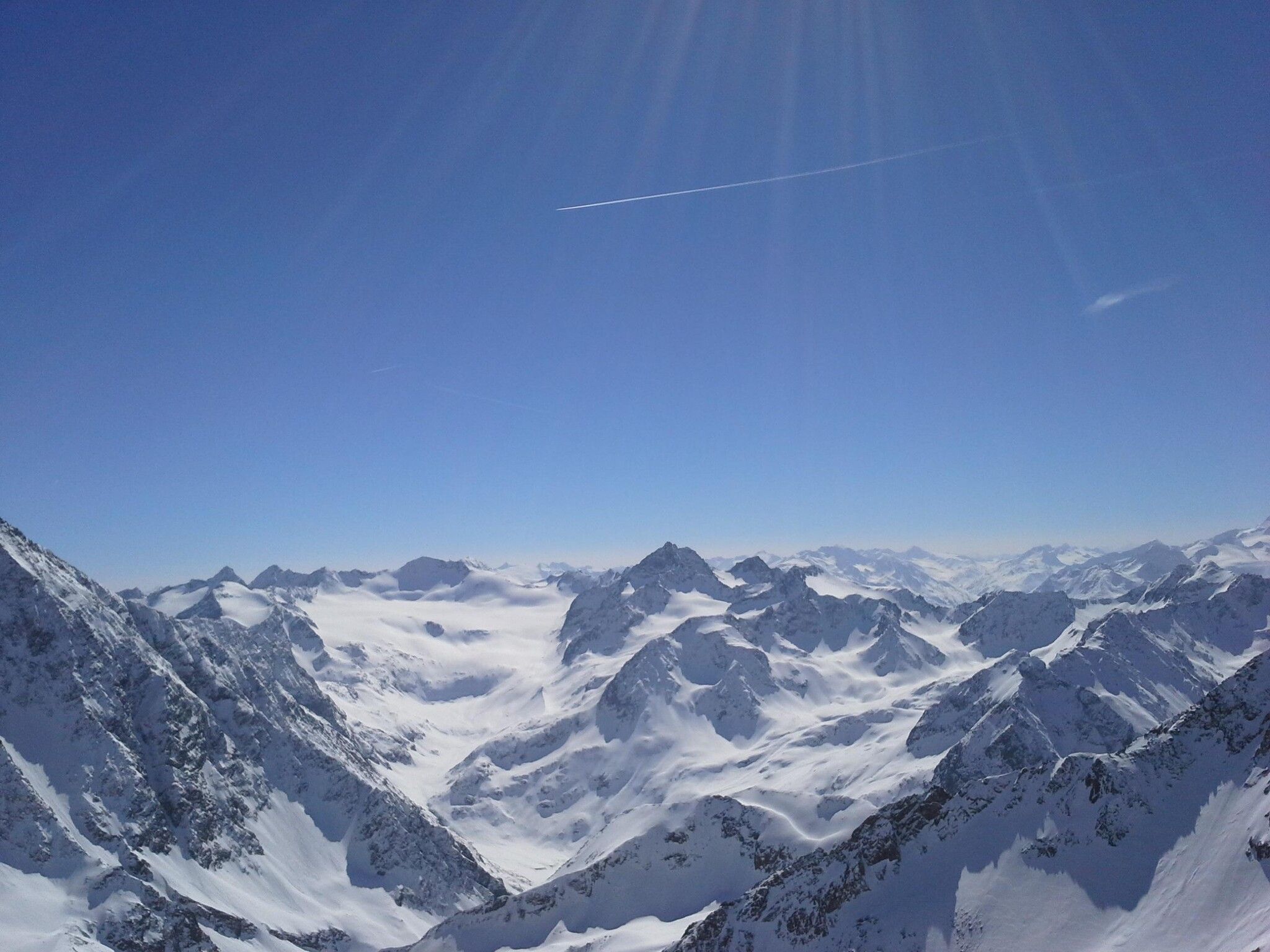
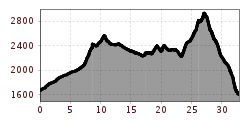
Weitwandern Etappe 3 Winterlandschaft (1).jpg © Region Seefeld, Johannes Geyer Complete Route for the Tyrol’s 1. Winter Multi-day HikeOpening hours:openDifficulty:mediumLength:48.0 kmDuration:4 daysElevation uphill:1,000 mGo to winter hikeGo to winter hike: Complete Route for the Tyrol’s 1. Winter Multi-day Hike
Innsbruck Hafelekar - Karwendel Hoehenweg Etappe 3 © Region Seefeld - Bizcomburnz Karwendel High TrailDifficulty:difficultLength:70.0 kmDuration:6 daysElevation uphill:4,470 mSee trailSee trail: Karwendel High Trail
Bad Kissinger Hütte Außenansicht © Bad Kissinger Hütte Over the Tannheim mountains | 4-day tourDifficulty:mediumLength:35.0 kmDuration:15:00 hElevation uphill:2,200 mSee trailSee trail: Over the Tannheim mountains | 4-day tour
hubertuskapelle-ströden-c-berny-steiner.jpg © Berny Steiner Pilgerweg Prägraten a.G.Difficulty:mediumLength:33.1 kmElevation uphill:2,793 mSee trailSee trail: Pilgerweg Prägraten a.G.
hochundheilig-stage4-hollbruck-c-peter-maier.jpg © Peter Maier High and sacred – an Alpine pilgrim trail through East Tyrol, South Tyrol and Upper CarinthiaDifficulty:mediumLength:191.6 kmDuration:77:45 hElevation uphill:10,475 mSee trailSee trail: High and sacred – an Alpine pilgrim trail through East Tyrol, South Tyrol and Upper Carinthia
2023_TVB-Ischgl-Paznaun_Sommer_Cross-Trail_Gruebele-See_WEST_3267.jpg © TVB Paznaun-Ischgl 01 Premium long-distance hiking trail - High route PaznaunDifficulty:mediumLength:138.6 kmDuration:9 daysElevation uphill:10,316 mSee trailSee trail: 01 Premium long-distance hiking trail - High route Paznaun
unweit der Gramai Alm - Blick zur Lamsenspitze © Achensee Tourismus Karwendel tourDifficulty:difficultLength:44.2 kmDuration:4 daysElevation uphill:3,955 mSee trailSee trail: Karwendel tour
hochundheilig-etappe8-nikolauskirche-c-peter-maier.jpg © Peter Maier Talweg Matrei i. O.Difficulty:mediumLength:15.3 kmDuration:4:50 hElevation uphill:397 mSee trailSee trail: Talweg Matrei i. O.
Wilder Kaiser © Kaiser Hoch 6 - Kitzbüheler Bergführer Wilder-Kaiser-Steig - DetourDifficulty:difficultLength:33.0 kmDuration:16:49 hElevation uphill:2,311 mSee trailSee trail: Wilder-Kaiser-Steig - Detour
Panorama Südseite_Wilder Kaiser © TVB Wilder Kaiser/Mathäus Gartner Kaiserkrone - around the Wilder Kaiser in 5 daysDifficulty:mediumLength:57.7 kmDuration:5 daysElevation uphill:4,000 mSee trailSee trail: Kaiserkrone - around the Wilder Kaiser in 5 days
Kronburg Wallfahrtskirche © TirolWest Tiroler PilgerwegDifficulty:mediumLength:220.0 kmElevation uphill:1,840 mSee trailSee trail: Tiroler Pilgerweg
winterwander-kappl-see-2019 (83).jpg © TVB Paznaun-Ischgl 01 "Weiße Weiten” (White Vistas) winter long-distance trailDifficulty:mediumLength:52.7 kmDuration:14:00 hElevation uphill:1,579 mGo to winter hikeGo to winter hike: 01 "Weiße Weiten” (White Vistas) winter long-distance trail
MaucheleWA055.jpg © TVB Pitztal/Bernd Ritschl Kaunergrat Circular Route - 5 DaysDifficulty:difficultLength:42.5 kmDuration:5 daysElevation uphill:3,804 mSee trailSee trail: Kaunergrat Circular Route - 5 Days
Kaunergrathütte © TVB Pitztal/Roman Huber Kaunergrat Circular Route - 3 DaysDifficulty:difficultLength:22.8 kmDuration:3 daysElevation uphill:2,650 mSee trailSee trail: Kaunergrat Circular Route - 3 Days
Nature park house_with hiker.JPG © TVB Pitztal Kaunergrat Circular Route - 7 DaysDifficulty:difficultLength:66.4 kmDuration:7 daysElevation uphill:5,496 mSee trailSee trail: Kaunergrat Circular Route - 7 Days
Panorama Südseite_Wilder Kaiser © TVB Wilder Kaiser/Stefan Leitner 3-day hut tour Wilder KaiserDifficulty:difficultLength:24.6 kmDuration:14:00 hElevation uphill:2,060 mSee trailSee trail: 3-day hut tour Wilder Kaiser
Wildseeloderhaus © Toni Niederwieser WaiWi - from Waidring to the WildseeloderDifficulty:mediumLength:50.0 kmDuration:4 daysElevation uphill:3,200 mSee trailSee trail: WaiWi - from Waidring to the Wildseeloder
The Tyrolean section of The Way of St. James through InnsbruckDifficulty:easyLength:81.4 kmDuration:21:00 hElevation uphill:900 mSee trailSee trail: The Tyrolean section of The Way of St. James through Innsbruck
Fernwandern26.jpg © x Lechtaler HöhenwegDifficulty:difficultLength:70.0 kmDuration:41:00 hElevation uphill:6,100 mSee trailSee trail: Lechtaler Höhenweg
Potsdamer-Hütte.jpg © Innsbruck Tourismus The Sellrain Valley Mountain Hut TourDifficulty:difficultLength:84.3 kmDuration:7 daysElevation uphill:5,085 mSee trailSee trail: The Sellrain Valley Mountain Hut Tour
Kaiserlift Wandern Naturerlebnis Kaisergebirge © Sportalpen Marketing 2-day mountain tour Güttlersteig to SonneckDifficulty:difficultLength:15.0 kmDuration:12:30 hElevation uphill:2,330 mSee trailSee trail: 2-day mountain tour Güttlersteig to Sonneck
web-wandern-weitwandern-wilder-kaiser-foto-von-felbert-reiter-177©danielreiterpetervonfelbert.jpg © Daniel Reiter /Peter von Felbert Two days tour Wilder KaiserDifficulty:difficultLength:42.5 kmDuration:15:57 hElevation uphill:2,475 mSee trailSee trail: Two days tour Wilder Kaiser
Kufstein Stadtplatz Marienbrunnen © Lolin EUREGIO Mary Way-M1Difficulty:mediumLength:84.1 kmDuration:25:01 hElevation uphill:2,238 mSee trailSee trail: EUREGIO Mary Way-M1
Blick vom Rofangebirge in den Sonnenuntergang © Achensee Tourismus Rofan tourDifficulty:mediumLength:30.5 kmDuration:4 daysElevation uphill:1,450 mSee trailSee trail: Rofan tour
Arlberg_Marketing_Arlbergtrail_WEST © West Werbeagentur GmbH Arlberg TrailDifficulty:difficultLength:52.1 kmElevation uphill:4,730 mSee trailSee trail: Arlberg Trail
Give feedback for a chance to win a special holiday experience!Click here for the surveyClick here for the survey


.jpg")


.jpg")


