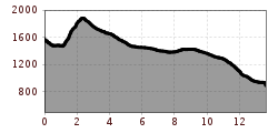
Open interactive mapOpen this POI on the interactive mapElevation profiledownload3-Tages-Tour Wilder.gpx
Ansicht Stripsenjochhaus © Claudia Moritz Stripsenjoch HouseOpening hours:Open todayPlace:Ebbs:Alpine pasture / hut / mountain restaurantsee restaurant detailssee restaurant details: Stripsenjoch House
Pfandlhof Kaisertal Wandern Hütte Einkehr © Lolin Mountain inn PfandlhofOpening hours:Today closedPlace:Ebbs:Alpine pasture / hut / mountain restaurantsee restaurant detailssee restaurant details: Mountain inn Pfandlhof
Lechtal, Lechtaler Höhenweg, Steinsee_Tirol Werbung_Schels Sebastian_No location given (4) © Tirol Werbung | Sebastian Schels Lechtaler HöhenwegDifficulty:difficultLength:84.5 kmDuration:45:00 hElevation uphill:6,773 mSee trailSee trail: Lechtaler Höhenweg
Lechtaler Alpen-Zams, Steinseehütte, von Hanauerhütte bis Württemberger Haus, Adlerweg, Etappe 20_Tirol Werbung_Gigler Dominik_Zams (1).jpg © Gigler Dominik Eagle Walk TirolDifficulty:difficultLength:426.0 kmElevation uphill:30,000 mSee trailSee trail: Eagle Walk Tirol
Gogles Alm © Gogles Alm/Joachim E5 Konstanz - Oberstdorf - MeranDifficulty:difficultSee trailSee trail: E5 Konstanz - Oberstdorf - Meran
Kitzbüheler Alpen_KATwalk2018-Etappe4_Erwin Haiden07.jpg © Erwin Haiden KAT WALK ALPINEDifficulty:mediumLength:113.0 kmDuration:45:00 hElevation uphill:6,300 mSee trailSee trail: KAT WALK ALPINE
Weitwanderung Peter Habeler Runde © Archiv TVB Mayrhofen Long-distance hike: Peter Habeler RundeDifficulty:difficultLength:56.7 kmDuration:25:00 hElevation uphill:3,705 mSee trailSee trail: Long-distance hike: Peter Habeler Runde
Schloss Bruck Lienz © TVBOsttirol Walter Mair Trail Lienzer TalbodenDifficulty:easyLength:48.0 kmDuration:15:40 hElevation uphill:1,280 mSee trailSee trail: Walter Mair Trail Lienzer Talboden
Jakobsweg - Osttirol StagesDifficulty:mediumLength:67.7 kmDuration:21:00 hElevation uphill:1,765 mSee trailSee trail: Jakobsweg - Osttirol Stages
hoch-tirol-trail-abstieg-umbaltal-chl2322-c-geomarketing-christjanladurner.jpg © Geomarketing - Christjan Ladurner Hoch Tirol TrailDifficulty:difficultLength:28.9 kmDuration:12:30 hElevation uphill:1,519 mSee trailSee trail: Hoch Tirol Trail
Ausblick von der Kapelle Maria Heimsuchung © Sportalpen Marketing EUREGIO-Maria-Weg-M5Difficulty:easyLength:166.6 kmDuration:46:16 hElevation uphill:2,971 mSee trailSee trail: EUREGIO-Maria-Weg-M5
EUREGIO Marien-Weg-M6Difficulty:easyLength:12.1 kmDuration:3:38 hElevation uphill:268 mSee trailSee trail: EUREGIO Marien-Weg-M6
EUREGIO-Marien-Weg-M3Difficulty:easyLength:179.0 kmDuration:52:17 hElevation uphill:3,190 mSee trailSee trail: EUREGIO-Marien-Weg-M3
Thierberg Kapelle Wandern © Sportalpen Marketing EUREGIO-Maria-Weg-M4Difficulty:easyLength:123.0 kmDuration:36:00 hElevation uphill:2,330 mSee trailSee trail: EUREGIO-Maria-Weg-M4
The Tyrolean section of The Way of St. James through InnsbruckDifficulty:easyLength:81.4 kmDuration:21:00 hElevation uphill:900 mSee trailSee trail: The Tyrolean section of The Way of St. James through Innsbruck
Wildseeloderhaus © Toni Niederwieser WaiWi - from Waidring to the WildseeloderDifficulty:mediumLength:50.0 kmDuration:24:00 hElevation uphill:3,200 mSee trailSee trail: WaiWi - from Waidring to the Wildseeloder
Alpbachtal Hüttenjause auf der Farmkehralm © Mathäus Gartner 3-day Family Tour AlpbachtalDifficulty:easyLength:18.3 kmDuration:7:00 hElevation uphill:998 mSee trailSee trail: 3-day Family Tour Alpbachtal
Kronburg Wallfahrtskirche © TirolWest Tiroler PilgerwegDifficulty:mediumLength:220.0 kmElevation uphill:1,840 mSee trailSee trail: Tiroler Pilgerweg
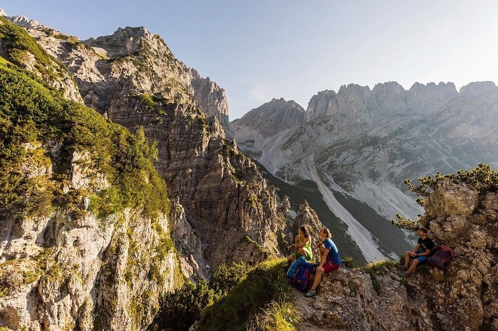
Panorama Südseite_Wilder Kaiser © TVB Wilder Kaiser/Mathäus Gartner Kaiserkrone - around the Wilder Kaiser in 5 daysDifficulty:mediumLength:57.7 kmDuration:27:00 hElevation uphill:4,000 mSee trailSee trail: Kaiserkrone - around the Wilder Kaiser in 5 days
winterwander-kappl-see-2019 (83).jpg © TVB Paznaun-Ischgl 01 "Weiße Weiten” (White Vistas) winter long-distance trailDifficulty:mediumLength:52.7 kmDuration:14:00 hElevation uphill:1,579 mGo to winter hikeGo to winter hike: 01 "Weiße Weiten” (White Vistas) winter long-distance trail
EUREGIO Marien-Weg-M7Difficulty:easyLength:50.8 kmDuration:15:20 hElevation uphill:984 mSee trailSee trail: EUREGIO Marien-Weg-M7
Karwendelhaus mit Bergpanorama © Region Seefeld, Miriam Mayer Karwendelmarsch 52 kmDifficulty:mediumLength:53.5 kmDuration:19:00 hElevation uphill:2,180 mSee trailSee trail: Karwendelmarsch 52 km
Kaunergrathütte © TVB Pitztal/Roman Huber Kaunergrat Circular Route - 3 DaysDifficulty:difficultLength:22.8 kmDuration:13:00 hElevation uphill:2,650 mSee trailSee trail: Kaunergrat Circular Route - 3 Days
MaucheleWA055.jpg © TVB Pitztal/Bernd Ritschl Kaunergrat Circular Route - 5 DaysDifficulty:difficultLength:42.5 kmDuration:23:00 hElevation uphill:3,804 mSee trailSee trail: Kaunergrat Circular Route - 5 Days
Naturparkhaus_mit Wanderer.JPG © TVB Pitztal Kaunergrat Circular Route - 7 DaysDifficulty:difficultLength:66.4 kmElevation uphill:5,496 mSee trailSee trail: Kaunergrat Circular Route - 7 Days
Give feedback for a chance to win a special holiday experience!Click here for the surveyClick here for the survey


")
.jpg")


.jpg")


