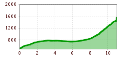
Open interactive mapOpen this POI on the interactive mapElevation profiledownload3-Tages-Tour Wilder.gpx
Ansicht Stripsenjochhaus © Claudia Moritz Stripsenjoch HouseOpening hours:Open todayPlace:Ebbs:Alpine pasture / hut / mountain restaurantsee restaurant detailssee restaurant details: Stripsenjoch House
Pfandlhof Kaisertal Wandern Hütte Einkehr © Lolin Mountain inn PfandlhofOpening hours:Open todayPlace:Ebbs:Alpine pasture / hut / mountain restaurantsee restaurant detailssee restaurant details: Mountain inn Pfandlhof
2023_TVB-Ischgl-Paznaun_Sommer_Cross-Trail_Gruebele-See_WEST_3267.jpg © TVB Paznaun-Ischgl 01 Premium long-distance hiking trail - High route PaznaunDifficulty:mediumLength:138.6 kmDuration:60:00 hElevation uphill:10,316 mSee trailSee trail: 01 Premium long-distance hiking trail - High route Paznaun
unweit der Gramai Alm - Blick zur Lamsenspitze © Achensee Tourismus Karwendel tourDifficulty:difficultLength:44.2 kmDuration:24:00 hElevation uphill:3,955 mSee trailSee trail: Karwendel tour
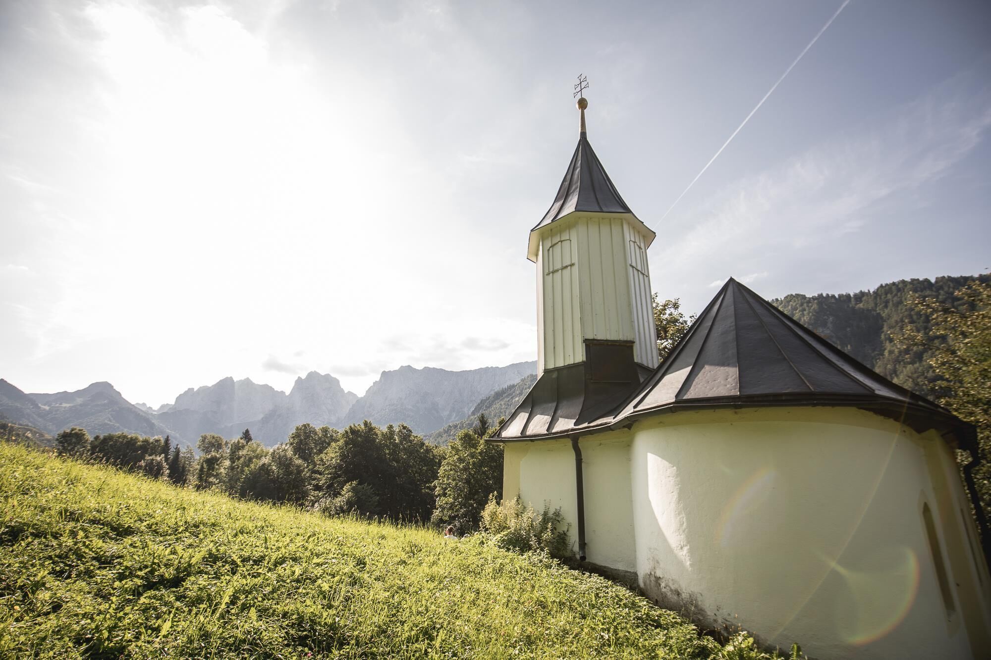
hochundheilig-etappe8-nikolauskirche-c-peter-maier.jpg © Peter Maier Talweg Matrei i. O.Difficulty:mediumLength:15.3 kmDuration:4:50 hElevation uphill:397 mSee trailSee trail: Talweg Matrei i. O.
Füssener Hütte © Rene Paulweber Through the Tannheim mountains | 4-day tourDifficulty:mediumLength:35.0 kmDuration:15:00 hElevation uphill:2,200 mSee trailSee trail: Through the Tannheim mountains | 4-day tour
KarwendeltourDifficulty:mediumLength:41.0 kmDuration:15:50 hElevation uphill:1,875 mSee trailSee trail: Karwendeltour
hochundheilig-etappe4-hollbruck-c-peter-maier.jpg © Peter Maier High and sacred – an Alpine pilgrim trail through East Tyrol, South Tyrol and Upper CarinthiaDifficulty:mediumLength:191.6 kmDuration:77:45 hElevation uphill:10,475 mSee trailSee trail: High and sacred – an Alpine pilgrim trail through East Tyrol, South Tyrol and Upper Carinthia
Dürrenberg © Rene Paulweber / Fotostudio Rene Circular Route Around the Valley Basin | 3-Day Hiking TourDifficulty:mediumLength:32.0 kmDuration:15:00 hElevation uphill:2,459 mSee trailSee trail: Circular Route Around the Valley Basin | 3-Day Hiking Tour
Blick auf die Gramai Alm © Gramai Alm Karwendel 3-day-hike: Pertisau - Lamsenjochhütte - Eng Alm - Plumsjoch - PertisauDifficulty:mediumLength:37.1 kmDuration:13:00 hElevation uphill:1,615 mSee trailSee trail: Karwendel 3-day-hike: Pertisau - Lamsenjochhütte - Eng Alm - Plumsjoch - Pertisau
Panorama Südseite_Wilder Kaiser © TVB Wilder Kaiser/Stefan Leitner 3-day hut tour Wilder KaiserDifficulty:difficultLength:24.6 kmDuration:14:00 hElevation uphill:2,060 mSee trailSee trail: 3-day hut tour Wilder Kaiser
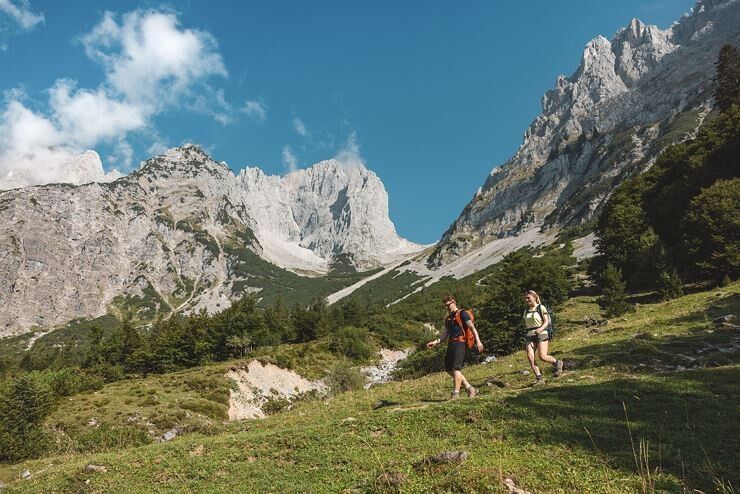
web-wandern-weitwandern-wilder-kaiser-foto-von-felbert-reiter-164©danielreiterpetervonfelbert.jpg © Daniel Reiter /Peter von Felbert 3-Tages-Tour WilderDifficulty:difficultLength:13.6 kmDuration:7:09 hElevation uphill:694 mSee trailSee trail: 3-Tages-Tour Wilder
iseltrail-etappe2-feldner-katarakte-c-ramona-walder.jpg © TVB Osttirol/Waldner Ramona IseltrailDifficulty:mediumLength:75.3 kmDuration:24:30 hElevation uphill:2,347 mSee trailSee trail: Iseltrail
Peter Habeler RundeDifficulty:difficultLength:41.3 kmDuration:17:00 hElevation uphill:2,236 mSee trailSee trail: Peter Habeler Runde
wandern-blickaufprossegg-c-desiree-dezordo.jpg © Desirèe De Zordo Trail Virgentaler SonnseitenwegDifficulty:mediumLength:41.9 kmDuration:19:00 hElevation uphill:2,641 mSee trailSee trail: Trail Virgentaler Sonnseitenweg
3-Tages-Tour WilderDifficulty:difficultLength:34.3 kmDuration:16:00 hElevation uphill:2,550 mSee trailSee trail: 3-Tages-Tour Wilder
hubertuskapelle-ströden-c-berny-steiner.jpg © Berny Steiner Pilgerweg Prägraten a.G.Difficulty:mediumLength:33.1 kmDuration:27:00 hElevation uphill:2,793 mSee trailSee trail: Pilgerweg Prägraten a.G.
GEsamtweg©_Peter_Maier_Hoefe_Trail (41).jpg © Peter Maier The Höfe TrailDifficulty:easyLength:51.2 kmDuration:10:15 hElevation uphill:1,988 mSee trailSee trail: The Höfe Trail
Stripsenjoch Stripsenkop Stripsenjochhaus Wandern Kaisergebirge © Michael Schirnhofer 2-Day High-Altitude Tour around Kaisertal - OverviewOpening hours:openDifficulty:mediumLength:25.9 kmDuration:12:00 hElevation uphill:2,230 mSee trailSee trail: 2-Day High-Altitude Tour around Kaisertal - Overview
Karwendelhaus mit Bergpanorama © Region Seefeld, Miriam Mayer Karwendelmarsch 52 kmDifficulty:mediumLength:53.5 kmDuration:19:00 hElevation uphill:2,180 mSee trailSee trail: Karwendelmarsch 52 km
Naturparkhaus_mit Wanderer.JPG © TVB Pitztal Kaunergrat Circular Route - 7 DaysDifficulty:difficultLength:66.4 kmElevation uphill:5,496 mSee trailSee trail: Kaunergrat Circular Route - 7 Days
MaucheleWA055.jpg © TVB Pitztal/Bernd Ritschl Kaunergrat Circular Route - 5 DaysDifficulty:difficultLength:42.5 kmDuration:23:00 hElevation uphill:3,804 mSee trailSee trail: Kaunergrat Circular Route - 5 Days
Kaunergrathütte © TVB Pitztal/Roman Huber Kaunergrat Circular Route - 3 DaysDifficulty:difficultLength:22.8 kmDuration:13:00 hElevation uphill:2,650 mSee trailSee trail: Kaunergrat Circular Route - 3 Days
hintere-ochsenalm-blick-lapawitzkees-glocknergruppe-c-eva-oberhauser.jpg © Eva Oberhauser Großglockner trekDifficulty:difficultLength:86.1 kmElevation uphill:7,209 mSee trailSee trail: Großglockner trek
Adlerweg Logo © TVB Osttirol Adlerweg trail through OsttirolDifficulty:difficultLength:93.3 kmElevation uphill:7,101 mSee trailSee trail: Adlerweg trail through Osttirol
wanderung-grosser-zunig-wokenmeer-c-bernhard-assmair.jpg © Bernhard Aßmair Lasörling altitude trailDifficulty:mediumLength:55.4 kmDuration:25:00 hElevation uphill:3,718 mSee trailSee trail: Lasörling altitude trail
loebbentoerl-schlatenkees-sommer-2024-c-bernhard-assmair.JPG © Bernhard Aßmair Venediger altitude trailDifficulty:difficultLength:55.5 kmDuration:27:00 hElevation uphill:3,975 mSee trailSee trail: Venediger altitude trail
Give feedback for a chance to win a special holiday experience!Click here for the surveyClick here for the survey


.jpg")


