
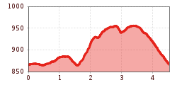
A medium-length circular walk that passes well-known highlights in the Hungerburg area while also following some of the less common paths.
From the starting point in the Hungerburg district, first head west along the low-traffic paved road to Gramartboden. From there, the route starts along a steep forest road but soon joins a wonderful, flat and very beautiful forest path. Follow this path east through Innsbruck's city forest and then along the "Maria im Walde" trail, past the small shrine of the same name and all the way to the Kreuzbrunnen fountain. From there, the route leads pleasantly downhill, crossing under the Nordkettenbahn cable car to join the Rosnerweg trail, which leads west back to the starting point.


