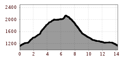
Trail running Hinterhornbach - Kanzberg - Jochbachtal - Hinterhornbach

Hinterhornbach / Allgäu Alps
Route length: 14.2 km

Hinterhornbach - Kanzberg - Jochbachtal - Hinterhornbach

Tour information

  • Length: 14.2 km
  • Elevation uphill:1,240 hm
  • Elevation downhill:1,240 hm
Highest point2,140 m

Starting point

Hinterhornbach -

Finishing point

Hinterhornbach -

Best time of year

  • January
  • February
  • March
  • April
  • May
  • June
  • July
  • August
  • September
  • October
  • November
  • December
Source: TVB Lechtal

Weather

Today

light rain showers
20°C/10°C
50%1.1l5 km/h

Fri

clear sky
23°C/8°C
0%0l5 km/h

Sat

mainly clear
27°C/10°C
75%2.7l5 km/h
Go to weather forecast

More tours in the surrounding area

Newsletter

The mountain is calling? So does our newsletter!

In our monthly newsletter we reveal the best holiday tips for Tyrol.